Bogotá – La Sabana 2050
Bogotá, Colombia, 2018

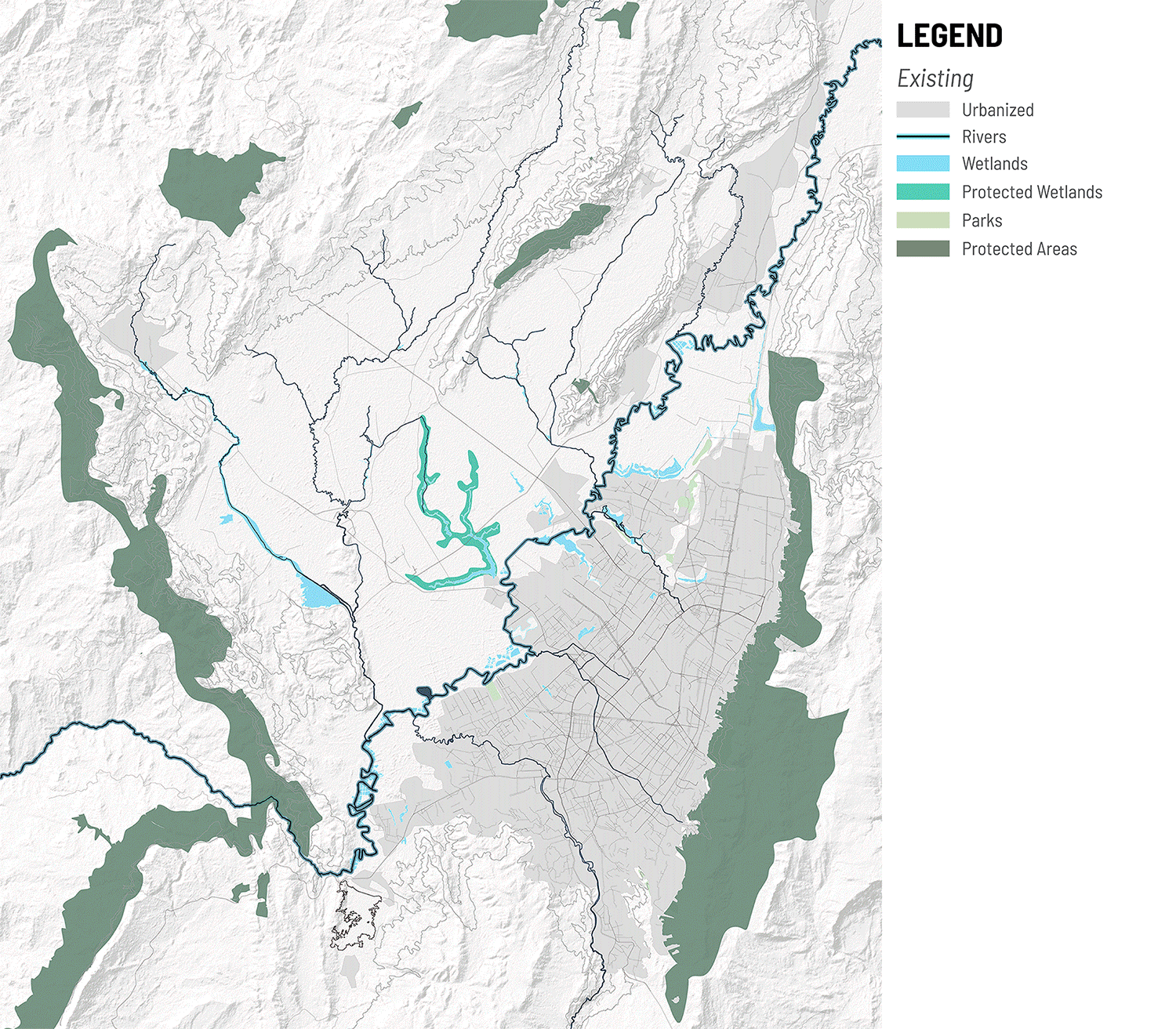
Figure 1. The city of Bogotá, the capital of Colombia located in the Tropical Andes Hotspot
Bogotá was chosen as an exemplary case study because it is a very rapidly city in the world’s 3rd most biodiverse nation, Colombia, and also because its urban growth is both formal (planned) and informal (unplanned/self-constructed). [1] Adding to its relevance, not only is Bogota sprawling into habitat harboring endangered species, it is also sprawling into its own food-bowl, the rich agricultural lands directly adjacent to the city known as the Sabana (savanah) de Bogotá And finally, Bogota doesn’t have a regional plan that aspires to integrating these conflicting land uses. As such, creating a regional plan that integrates formal and informal urban growth with biodiversity and agricultural lands could, we believe, not only contribute to the city of Bogotá but also serve as a model for other hotspot cities. Through a research-by-design process we demonstrate how conservation values and urban development can be symbiotic and how this symbiosis can be explicitly reflected in the spatial planning of the city.
The plan for Bogotá – La Sabana 2050 is fundamentally organized around an ecological network determined by forging connectivity between patches of protected areas and buffering the hydrological system of the Sabana and the Río Bogotá. To achieve this, existing large-scale protected areas in the regional context are connected to peri-urban areas of remnant habitat, which in turn are connected to riparian zones and wetlands. The future urban growth of Bogota is then integrated with and shaped by the ecological network. New urban districts proposed in the plan are set out along a new transit loop linking to the new airport. These districts are mixed use, walkable, transit-oriented developments that include and allow for a degree of informal urban development. The urban morphology is adjusted at its edges to meet the organic form of the ecological network. By the same token, the ecological network has been adjusted—tightened, and in parts realigned—so as to help achieve functional and legible urban form.
The dichotomy between conservation and urbanization can be overcome by envisioning urban design as a process of compromise in which both urban logistics and the ecological imperatives perform as a single system, each adding value to the other. This requires deep and culturally specific understanding of how both the ecosystem and the urban development system function as well as incentives to mobilize change away from the status quo of socially and ecologically irresponsible growth.
For a full description of this case study see Weller, Gouverneur, Drozdz, and Ye (2021).
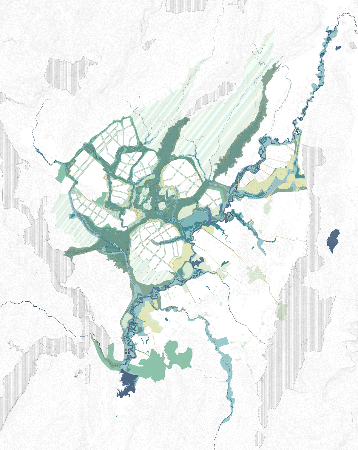
Figure 2. The ecological network.

Figure 3. The urban network.

Figure 4. Final Masterplan for Bogotá – La Sabana 2050.
Acknowledgements
We wish to thank Diego Bermudez, our colleague and friend in Bogota, and the students who worked on this project: Yifan Cai, Yu-Te Chiang, Mariela Hernandez, Terence Hogan, Ruobing Huang, Yichao Jia, Meichun Jia, Hong Li, Xuanang Li, Zhiyu Weio.
[1] CEPF, “Tropical Andes: About this Hotspot,” https://www.cepf.net/our-work/biodiversity-hotspots/tropical-andes. (accessed December 20, 2018).