Ciudad de México, Mexico
- Global Location plan: 19.43oN, 99.13oW[1]
- Ecoregions: Trans-Mexican Volcanic Belt Pine-Oak Forest and Central Mexican Matorral Ecoregion
- Population 2016: 21,157,000[2]
- Projected population 2030: 23,865,000[3]
- Mascot Species: Volcano Rabbit
Endangered species
Amphibians
- Agalychnis dacnicolor
- Rhinella marina
- Rheohyla miotympanum
- Anaxyrus punctatus
- Sarcohyla robertsorum
- Pseudoeurycea melanomolga
- Pseudoeurycea lynchi
- Scinax staufferi
- Incilius nebulifer
- Incilius occidentalis
- Agalychnis moreletii
- Dryophytes eximius
- Tlalocohyla picta
- Exerodonta xera
- Smilisca baudinii
- Craugastor augusti
- Eleutherodactylus cystignathoides
- Craugastor decoratus
- Craugastor hobartsmithi
- Eleutherodactylus nitidus
- Leptodactylus fragilis
- Engystomops pustulosus
- Gastrophryne elegans
- Lithobates berlandieri
- Ambystoma velasci
- Chiropterotriton dimidiatus
- Chiropterotriton mosaueri
- Chiropterotriton terrestris
- Pseudoeurycea leprosa
- Thorius magnipes
- Thorius troglodytes
- Notophthalmus meridionalis
- Dermophis oaxacae
- Eleutherodactylus verruculatus
- Ambystoma ordinarium
- Eleutherodactylus verrucipes
- Spea multiplicata
- Hypopachus variolosus
- Sarcohyla charadricola
- Dryophytes euphorbiaceus
- Ambystoma tigrinum
- Ambystoma lermaense
- Ambystoma mexicanum
- Pseudoeurycea tlilicxitl
- Lithobates catesbeianus
- Incilius cristatus
- Dryophytes arenicolor
- Sarcohyla pentheter
- Trachycephalus typhonius
- Lithobates tlaloci
- Pseudoeurycea mixteca
- Aquiloeurycea quetzalanensis
- Eleutherodactylus longipes
- Leptodactylus melanonotus
- Chiropterotriton chondrostega
- Pseudoeurycea longicauda
- Anaxyrus compactilis
- Incilius marmoreus
- Rhinophrynus dorsalis
- Sarcohyla arborescandens
- Sarcohyla bistincta
- Tlalocohyla godmani
- Dryophytes plicatus
- Exerodonta smaragdina
- Tlalocohyla smithii
- Charadrahyla taeniopus
- Craugastor berkenbuschii
- Eleutherodactylus grandis
- Eleutherodactylus maurus
- Craugastor mexicanus
- Craugastor rhodopis
- Craugastor rugulosus
- Craugastor vocalis
- Lithobates chichicuahutla
- Lithobates megapoda
- Lithobates montezumae
- Lithobates neovolcanicus
- Lithobates pueblae
- Lithobates spectabilis
- Lithobates zweifeli
- Craugastor loki
- Ambystoma altamirani
- Ambystoma bombypellum
- Ambystoma granulosum
- Ambystoma leorae
- Ambystoma rivulare
- Ambystoma taylori
- Bolitoglossa platydactyla
- Bolitoglossa rufescens
- Chiropterotriton arboreus
- Chiropterotriton chondrostega
- Chiropterotriton multidentatus
- Chiropterotriton orculus
- Pseudoeurycea altamontana
- Isthmura bellii
- Aquiloeurycea cephalica
- Pseudoeurycea firscheini
- Pseudoeurycea gadovii
- Isthmura gigantea
- Pseudoeurycea leprosa
- Pseudoeurycea robertsi
- Pseudoeurycea robertsi
- Thorius dubitus
Mammals
- Otospermophilus variegatus
- Bassariscus sumichrasti
- Orthogeomys hispidus
- Sylvilagus floridanus
- Eumops underwoodi
- Megadontomys nelsoni
- Tadarida brasiliensis
- Myotis auriculus
- Myotis fortidens
- Nelsonia goldmani
- Pteronotus davyi
- Nyctinomops laticaudatus
- Nyctinomops laticaudatus
- Peromyscus pectoralis
- Cratogeomys fumosus
- Peromyscus melanotis
- Peromyscus mexicanus
- Peromyscus difficilis
- Peromyscus aztecus
- Peromyscus bullatus
- Peromyscus levipes
- Peromyscus megalops
- Rhogeessa tumida
- Reithrodontomys fulvescens
- Sylvilagus gabbi
- Molossus sinaloae
- Diaemus youngi
- Reithrodontomys microdon
- Microtus mexicanus
- Reithrodontomys sumichrasti
- Myotis elegans
- Baeodon alleni
- Baeodon gracilis
- Cryptotis mexicana
- Sorex saussurei
- Osgoodomys banderanus
- Lasiurus xanthinus
- Conepatus leuconotus
- Spilogale pygmaea
- Galictis vittata
- Ursus americanus
- Odocoileus virginianus
- Lasiurus cinereus
- Sorex veraecrucis
- Sorex orizabae
- Sturnira parvidens
- Sturnira hondurensis
- Platyrrhinus helleri
- Hodomys alleni
- Sorex mediopua
- Leptonycteris yerbabuenae
- Marmosa mexicana
- Cratogeomys perotensis
- Myotis occultus
- Nyctinomops macrotis
- Eumops ferox
- Promops centralis
- Peromyscus hylocetes
- Cratogeomys planiceps
- Cratogeomys fulvescens
- Peromyscus beatae
- Micronycteris microtis
- Cryptotis obscura
- Cynomops mexicanus
- Habromys schmidlyi
- Habromys delicatulus
- Neotoma leucodon
- Handleyomys rostratus
- Spilogale angustifrons
- Myotis keaysi
- Lasiurus ega
- Baiomys musculus
- Peromyscus gratus
- Oryzomys couesi
- Potos flavus
- Notocitellus adocetus
- Heteromys irroratus
- Heteromys pictus
- Tlacuatzin canescens
- Glossophaga morenoi
- Euderma maculatum
- Neotoma mexicana
- Cryptotis alticola
- Peromyscus furvus
- Microtus quasiater
- Pecari tajacu
- Nasua narica
- Corynorhinus mexicanus
- Mazama temama
- Antrozous pallidus
- Handleyomys chapmani
- Cryptotis parva
- Mus musculus
- Saccopteryx bilineata
- Mormoops megalophylla
- Chaetodipus hispidus
- Diclidurus albus
- Thomomys umbrinus
- Ototylomys phyllotis
- Lepus californicus
- Leptonycteris nivalis
- Urocyon cinereoargenteus
- Perognathus flavus
- Carollia sowelli
- Dipodomys phillipsii
- Dipodomys ornatus
- Chiroderma villosum
- Lasiurus intermedius
- Dasypus novemcinctus
- Herpailurus yagouaroundi
- Taxidea taxus
- Idionycteris phyllotis
- Myotis yumanensis
- Mephitis macroura
- Glossophaga commissarisi
- Puma concolor
- Romerolagus diazi
- Coendou mexicanus
- Uroderma magnirostrum
- Myotis velifer
- Sciurus aureogaster
- Dermanura azteca
- Lynx rufus
- Eira barbara
- Tapirus bairdii
- Dasyprocta mexicana
- Sigmodon mascotensis
- Sorex ventralis
- Glyphonycteris sylvestris
- Sciurus oculatus
- Sigmodon leucotis
- Neotomodon alstoni
- Bassariscus astutus
- Glossophaga leachii
- Didelphis virginiana
- Philander opossum
- Peromyscus perfulvus
- Noctilio leporinus
- Dipodomys ordii
- Xerospermophilus perotensis
- Reithrodontomys chrysopsis
- Anoura geoffroyi
- Ictidomys mexicanus
- Natalus mexicanus
- Procyon lotor
- Peromyscus mekisturus
- Molossus rufus
- Sylvilagus audubonii
- Myotis nigricans
- Habromys simulatus
- Megasorex gigas
- Notiosorex crawfordi
- Orthogeomys grandis
- Mimon cozumelae
- Myotis melanorhinus
- Canis latrans
- Peromyscus leucopus
- Lasiurus blossevillii
- Choeroniscus godmani
- Glaucomys volans
- Artibeus hirsutus
- Nyctinomops aurispinosus
- Myotis californicus
- Tamandua mexicana
- Eptesicus furinalis
- Balantiopteryx plicata
- Molossus aztecus
- Carollia perspicillata
- Lepus callotis
- Myotis volans
- Cuniculus paca
- Enchisthenes hartii
- Artibeus lituratus
- Baiomys taylori
- Didelphis marsupialis
- Choeronycteris mexicana
- Oligoryzomys fulvescens
- Sciurus deppei
- Desmodus rotundus
- Eptesicus brasiliensis
- Eptesicus fuscus
- Leopardus pardalis
- Lontra longicaudis
- Perimyotis subflavus
- Macrotus waterhousii
- Pteronotus personatus
- Tylomys nudicaudus
- Molossus molossus
- Musonycteris harrisoni
- Dermanura tolteca
- Myotis thysanodes
- Nyctomys sumichrasti
- Dermanura phaeotis
- Handleyomys alfaroi
- Cratogeomys merriami
- Peromyscus maniculatus
- Parastrellus hesperus
- Sigmodon alleni
- Artibeus jamaicensis
- Sorex oreopolus
- Ateles geoffroyi
- Caluromys derbianus
- Sylvilagus cunicularius
- Diphylla ecaudata
- Chiroderma salvini
- Glossophaga soricina
- Peromyscus melanophrys
- Centurio senex
- Reithrodontomys megalotis
- Reithrodontomys mexicanus
- Leopardus wiedii
- Corynorhinus townsendii
- Rhogeessa parvula
- Sigmodon toltecus
- Mustela frenata
Hotspot & Ecoregion Status
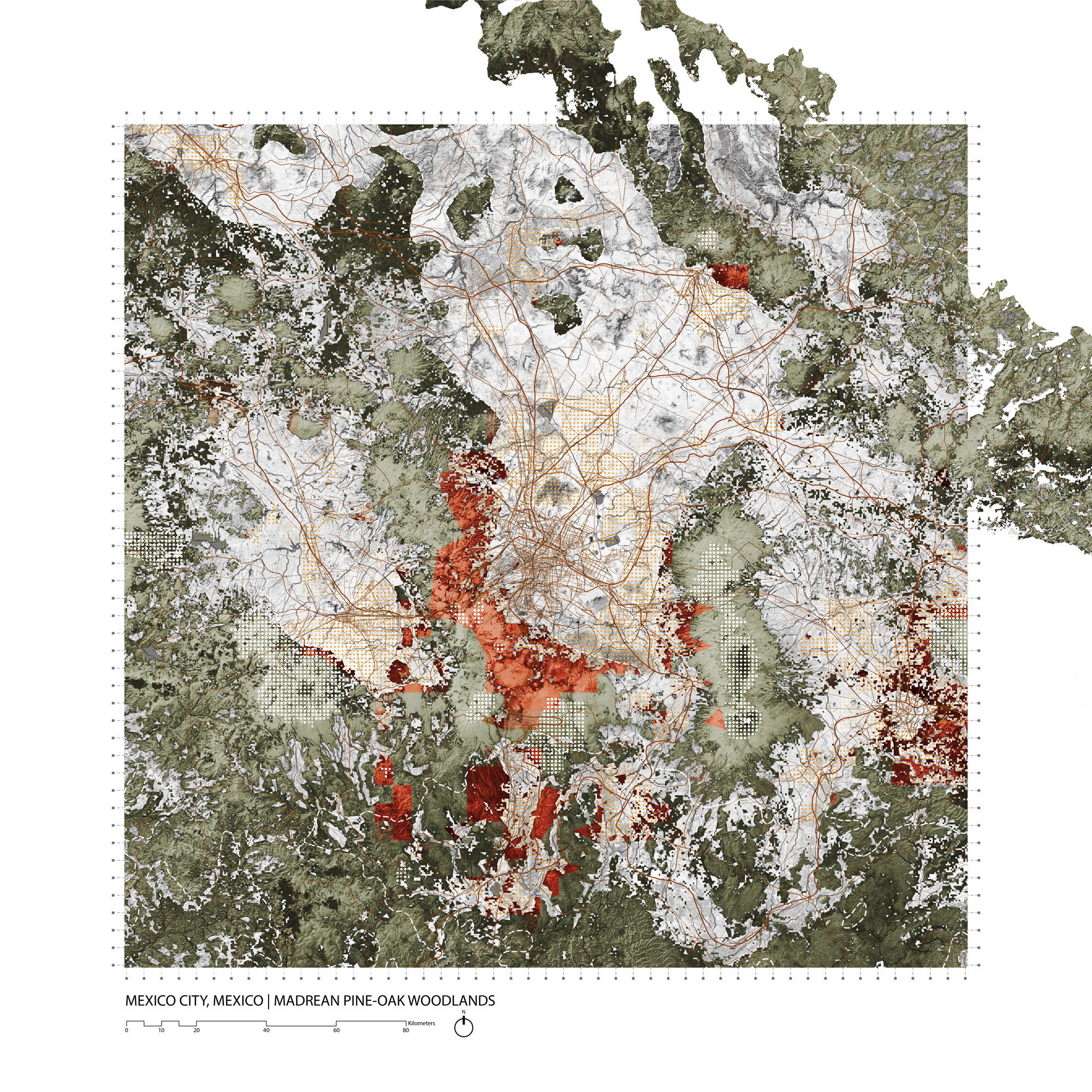
The Mexico City metropolitan area is centered in the Central Mexican Matorral Ecoregion, but has also grown to the southwest into the Trans-Mexican Volcanic Belt Pine-Oak Forest Ecoregion, which is in the Madrean Pine-Oak Woodlands Hotspot.
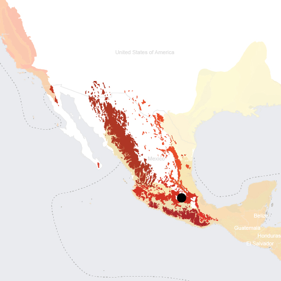
Madrean Pine-Oak Woodlands Hotspot
The Madrean Pine-Oak Woodlands is a “sky island” hotspot of higher elevation ecosystems that encompasses Mexico’s main mountain chains as well as 40 mountains in southern Arizona and New Mexico. Its rugged terrain is a manifestation of its complex geological history and underpins its great biological diversity. The climate is mostly temperate, though annual precipitation levels are highly variable, ranging between 500 and 2,500 millimeters.
[4]
Species Statistics [5]
|
|
Number of species |
Percentage/Number of endemics |
Notable species / Additional info |
|
Plants |
~5,300 |
~75% |
- important diversity center for oaks and pines |
|
Birds |
~525 |
>20 |
|
|
Mammals |
~330 |
6 |
- Endangered [6] volcano rabbit ( Romerolagus diazi ) |
|
Reptiles |
>380 |
~40 |
|
|
Amphibians |
~200 |
~50 |
|
|
Freshwater Fishes |
>80 |
~20 |
|
|
Invertebrates |
DD |
DD |
- known for 160-200 types of butterfly; 45 of which are endemic - monarch butterflies ( Danaus plexippus ) |
The primary threats to biodiversity in this hotspot are logging (especially of pines but increasingly oaks as well), unsustainable extraction and use of other forest species including epiphytes (sold as ornamental plants) and mushrooms (culinary use). Intentional burning for grazing is also a major threat. [7]
The Trans-Mexican Volcanic Belt Pine-Oak Forest Ecoregion
This ecoregion is a geological and ecological connector between the Sierra Madre Occidental and the Oriental mountain ranges. [9] The tallest mountain range in Mexico, it contains 13 of the highest peaks in Mexico and is an active volcanic arc about 60 miles wide at its widest and 400 miles long. It is a center of species diversity itself and further enriched by the diversity of its shoulder mountain regions. High levels of volcanic activity created many microhabitats which led to to radiation and speciation. [10]
Important ecosystems in this ecoregion include pine forests (which grow at elevations of 2,275-2,600 m), pine-oak forests (at 2,470-2,600 m), pine-cedar forests (above 2,700 m), and pine-fir forests (above 3,000 m). Pine-oak forests are important because most of the endemic and restricted-range vertebrates as well as the plant family Lamiaceae are only found here. They also support a rich herbaceous stratum and a plethora of epiphytes. [11]
These pine-oak forests, however, have been extensively degraded and exploited for timber (especially pine), and land clearing for agricultural purposes and highways and roads. They have also been subject to immense pressure from pollution and urbanization as half of the total Mexican population lives in the Trans-Volcanic belt . [12]
According to the European Commission’s Digital Observatory for Protected Areas, as of 2019, this ecoregion is 18% protected and 8.54% considered connected. [13]
Central Mexican Matorral Ecoregion
Although the Central Mexican Matorral ecoregion is not part of a designated hotspot, it is very biodiverse and contains the suburbs of Mexico City. It is representative of the Deserts and Xeric Shrublands biome, containing the southernmost portion of an extensive expanse of flatlands running south from the Mexico-US border. The geology of the area is primarily sedimentary in origin (in contrast to the Trans-Mexican Volcanic Belt which is primarily volcanic in origin). The climate is dry and hot, and annual precipitation levels are below 500mm. [14]
The central Mexican matorral has a great physiographic and floristic diversity. Because the region was isolated from other arid regions by Mexico’s three main mountain ranges, many endemic species evolved here. The dominant species of xeric shrublands in the area of the Valley of Mexico—where Mexico City is located—are O. streptacantha , Zaluzania augusta , Yucca filifera , Schinus molle , and Mimosa biuncifera . The ecoregion is particularly rich in herpetofauna and avifauna.
The primary threats to biodiversity are land clearing for agriculture, grazing. and urban growth. These processes have led to soil erosion, water pollution, and grave habitat damage. [15] According to the European Commission’s Digital Observatory for Protected Areas, as of 2019, this ecoregion is 5% protected and 2.38% considered connected. [16]
Environmental History
Mexico City sits at 2,240 m on an upland plateau within a lacustrine plain that has been desiccated over 500 years of human settlement, agriculture, and urbanization. This closed basin, with no natural drainage, historically held a series of lakes that occupied much of its low-lying areas. [17] The surrounding terrain is primarily of volcanic origin, though the different relief units vary greatly in age from the oldest Sierra de Guadalupe unit which is more than 2 million years old to the volcanoes of the Santa Catarina and Chichinautzin volcanic field which are less than 40 thousand years old. [18] Steep slopes of a variety of formations ring the city, with “mammoth volcanic peaks and towering mountains to the south and west, lower ridges to the east, and a high mesa to the north.” [19] These include the Pachuca mountain range to the north, the mountain range of Las Cruces, Monte Alto and Monte Bajo to the west, the Chichinautzin sierra to the south, the Tezontlalpan mountain range to the northwest. The highest volcanoes in the Sierra Nevada are located west of the city and aligned from south to north (including Popocatépetl at 5,400 m, Iztaccihuatl at 5,280 m, and Telapón and Tlaloc of the Sierra de Rio Frio which stand at about 4000 m each). [20]
The Mexica built the city of Tenochtitlan , the capital of their empire (also known as the Aztec empire) on an island in the middle of the lake system that once filled most of the Valley of Mexico. By the beginning of the 16th century, Tenochtitlan had a population between 200,000 and 300,000, and the population of the whole Valley of Mexico has been estimated to have been as high as two million. [21]
The lakes varied in depth depending on rainfall, which is highly season and also highly variable from year to year. The westen part of the lake system, which included Lake Texcoco, Lake Xaltocan and Lake Zumpango was brackish due to intense evaporation. What remains of this western system remains brackish today. As such, although the Mexica endured periodic intensive flooding of their city and they brought fresh water into the city via aqueduct. [22]
The environmental transformations of the 16th through the 18th century were relatively gradual yet fundamental. Extensive deforestation for grazing, firewood, charcoal and construction materials led to accelerated soil erosion that caused sedimentation of the lakes. The lake system was reduced by nearly 80% through the construction of drainage infrastructure intended to prevent flooding of the property of the Spanish colonial elite.
During the 19th century, Mexico City was known for lushness; visitors praised the thick forests of its nearby mountains, and the large lakes and fertile plains that surrounded the city. [23] But the volatile climate with its periods of intense flooding, led the ruling elite to invest extensively in drainage infrastructure.
To deal with intensive flooding, a 40 kilometer-long canal was completed in 1900 in order to drain Texcoco Lake to the North East to the Tula River through a tunnel under the mountains . Another deep, gravity-fed tunnel built in 1975 drained excess water to the North West to prevent flooding.
Lake Xochimilco was largely drained because of the demand for fresh water, and depleting not just the lake water but also the canals of the extensive, and once healthy, waterscape that the indigenous peasants used for their chinampería, an agricultural technique that uses dredging excavate canals and build up productive islands for growing food and flower crops.
Today, Lake Texcoco, the lowest lying part of the lake system, is also the largest remaining vestige of the extensive precolonial lakes.
Current Environmental Status & Major Challenges
Water
Water is the most significant environmental challenge facing Mexico City. The slow but methodical desiccation of this lacustrine valley, the incredible sprawl of the city, its vast paved areas, and its channelized rivers have created an incredibly precarious situation in terms of subsidence and unpredictable/limited water supply, especially to the most vulnerable populations of the city. In the poorest parts of the city, women cannot work because they have to stay home waiting for water deliveries, and these low income populations pay for water at much higher rates (up to 10x) than residents of more affluent neighborhoods. [24] Today, under normal conditions, sewage and storm water are pumped through a massive system of infrastructure and out of the valley, while 30 per cent of the city’s drinking water is pumped in from sources over 100 kilometres away.
The remaining water comes from artesian wells within the basin. This heavy reliance on groundwater in the city has resulted in overexploitation of the aquifer which has, in turn, caused extensive and severe subsidence in central Mexico City .
Threats to Ecosystems Necessary for the Supply of Water
An extensive forest called the Bosque de Agua (or the Great Water Forest) just beyond the mountain ranges to the south and west of Mexico City feeds two of the country’s largest rivers--the Lerma and the Balsas--and serves as a recharge zone for water percolating into four of the country’s most important aquifers. These aquifers supply two thirds of Mexico City’s metro area’s water. [25] Two other growing cities also depend on this forest for a significant portion of their water supply: Toluca and Cuernavaca.
This vital ecosystem, which occupies more than 600,000 acres, is important not just for the water it provides to the megacity, but also for the rural and indigenous communities that live within the forest. Many of the human inhabitants of the forest are comuneros , farmers descended from indigenous group who farm and manage their land in collectives. It has an incredible number of endemic species and is estimated to contain 2 percent of the world’s biodiversity. [26] Endangered Teporingos and Sierra Madre Sparrows, as well as pumas, bobcats, white-tailed deer and more than 10% if Mexico’s bird species are found in this forest. [27]
The Mexican National Commission for Knowledge and Use of Biodiversity (CONABIO) has called the Great Water Forest the Ajusco-Chinchinautzin Biological Corridor and designated it a priority conservation region. Already designated protected areas within the corridor include the national parks of La Marquesa, Ajusco, and Desierto de los Leones. [28] Yet although 80% of the forest has some kind of legal protection status, it is being cleared at an alarming rate that will destroy the whole forest in 50 years if it continues unabated. The primary threats to the forest include illegal logging, urban sprawl and highway building projects, but it is also threatened by clearing for cultivation and grazing as well as forest fires. Illegal logging is particularly driven by poverty as comuneros resort to the practice to get wood for cooking and heating. One of the primary challenges to protecting this invaluable forest tract is that it overlaps three political entities: Mexico City and Mexico and Morales states. No regional plan has been adopted to protect or plan for the long-term viability of this incredible ecosystem. [29] [30]
The steep slopes surrounding the valley have been prime locations for informal settlement. The irregular form of these settlements along with the steep grade that they are built on make it difficult to supply basic services, especially clean water, to these areas. While these areas relatively safe from the risks of earthquakes, they are vulnerable to landslides especially where the hills have been mined for building materials. On the other hand, settlements in the lake bed are vulnerable to earthquakes because the soils they are built on are highly compressible.
Growth Projections + Type of Growth
Urban Extent of Mexico City, 1990. Purple is characterized as urban built up, pink is suburban built up, yellow is urbanized open space, and green is rural open space.
[31]
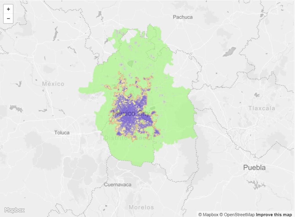
Urban Extent of Mexico City, 2014.
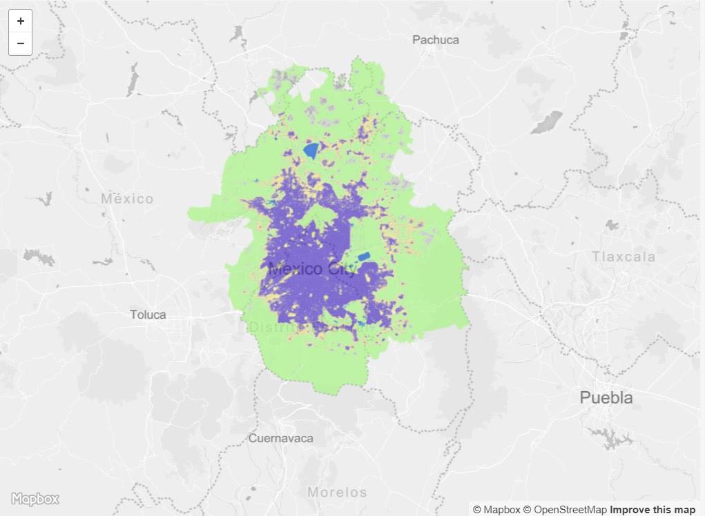
Mexico City grew intensively throughout most of the 20th century—especially after the 1910-1917 Revolution against the Porfirian dictatorship. The built up area of the city expanded from 23 square kilometers to 154,710 sq kilometers between the beginning and the end of the century. Even through this period of intensive growth, density levels have remained remarkably stable for 500 years at around 120 persons/hectare. The city has tended to grow horizontally during recessions and vertically during economic booms that make credit available for building. [32]
Starting in the 1940s, a wave of intensive industrialization was accompanied by intensive urbanization, much of it in the form of colonias populares : irregular, self-constructed, usually owner-occupied houses that became the primary form of housing for low and lower-middle class newcomers to the city. A UN-Habitat case study found that by 2003 more than half of the urbanized area of Mexico City was constituted by dwellings of this kind of informal origin and housed more than 60% of the population. Another 10% of the population lived in late 19th century houses abandoned by the wealthy and converted into tenements, and up to 15% lived in government financed public housing projects of variable quality including many projects that had been seriously deteriorated due to overcrowding and underfunding. [33]
While the city was historically located within the Federal District (which was recently renamed Mexico City or CDMX for short; see section on Governance), it began to grow to the north west into municipalities in the neighboring State of Mexico when new development was prohibited in the Federal District in the mid 1940s . [34] A large proportion of the cities growth between the 1940s and 1980s came from rural to urban migration of campesinos searching for work in the industrializing city. Many of these urban immigrants settled in the flood-prone dessicated lakebeds or in the foothills of the city. They suffered (and continue to suffer) from dust storms from the dried Texcoco lakened, land subsidence from aquifer overexploitation, and a severe deficiency of clean water supplies. [35]
Today Mexico City’s greater metropolitan area—including Cuernavaca to the southwest and Toluca to the west of the mountains surrounding Mexico City and the various municipalities whose urban areas have conurbated with it—has about 22 million inhabitants. About 43% of these inhabitants live within the boundaries of Mexico City (CDMX). [36] The metropolitan area is home to more than 15% of the national population. [37] According to the OECD the growth rate has slowed to 1.2% annually, after decades of rapid growth, primarily in the commuting zones. [38]
While we were not able to find a report with updated statistics regarding what percentage of city dwellers in Mexico City live in dwellings of illegal origin, there have been multiple studies that attest to the ongoing urban expansion by way of informal settlement. These studies have largely focused on specific informal occupations in an attempt to characterize the wide variety of circumstances and outcomes of ongoing informal settlements across the dynamic city periphery. [39] [40] These studies have also address the serious negative environmental impact of informal urban expansion into lands designated as conservation land. [41] [42]
The urban population growth rate has been declining since the 80s, but peripheral municipalities are growing at much faster rates than the city center. This is likely due to lack of affordable land in the center and availability of such land in the periphery. This urban expansion has been encroaching into land designated that is designated as a conservation zone. Most of the remaining conservation land around Mexico City is in nine municipalities, most of which are located south of the city. This conservation land is a mix of public, communally owned/leased, and private. Between 1970 and 1997, the conservation land has lost about 239 ha of forest cover and 173 ha of agricultural cover annually; settlement areas grew by about 298 ha annually. This conservation zone is critically important for aquifer recharge for an aquifer that supplies 57% of Mexico City’s water. Paving 1 sq. meter diverts 2000 to 2500 liters of rainwater from the aquifer annually. Municipalities with conservation land are the fastest growing and have the highest levels of “marginality.” [43]
From afar, the mayor’s office and the centralized planning entities seek stricter protections for the conservation lands, calling for zero expansion of informal settlements and restoration of degraded ecosystems; however these policy goals meet their greatest challenges at the local level where intense political pressure transforms urban planning into more of a negotiation than a decree. While the continued growth of informal settlements in conservation zones is often seen as a mark of lack of planning, the situation might be more accurately understood by seeing normative planning instruments as the frame within which local land use negations take place, as “the longstanding dialectical nature of [the relationship between the planning policy bodies and the local communities]”, i.e. as the “selective negotiation and application of existing planning frameworks rather than the lack of planning per se.” [44] Even the most highly regarded and closely protected areas such as the chinampas in Xochimilco—a landscape of historic canals that has been named a UNESCO world heritage site—has experienced the encroachment of informal settlements. The degradation of conservation lands spatially precedes the actual encroachment of settlements as well, as overexploitation of the aquifer has caused chinampas to dry out. [45]
Looking at Xochimilco as a case study in the southern urban zone of CDMX, Jill Wigle finds that the city’s strategy for dealing with loss of conservation land to urbanization is primarily mitigation rather than prevention. In Xochimilco, settlements are categorized based on their level of consolidation, which also seems to be a reliable measure of how old the settlements are. The more established/consolidated a settlement is, the more likely it is to win an appeal for a land-use change to residential use. Settlements that receive such a land use change must pay for “environmental damages” and enact “mitigation measures” Less consolidated/established settlements that are not granted a land use change continue to exist in a state of insecure land tenure. The model of formalizing irregular settlements according to the supposedly objective/rational measure of consolidation (one that in reality is greatly shaped by politics), encourages what is locally called mancha hormiga (ant-like sprawl) as small settlements take hold under the radar and slowly build up their amenities such that by the time they get noticed by officially, they are consolidated enough that removing them or delimiting their growth becomes too difficult.
Wigle also finds that the degradation of these conservation lands takes place through the accumulation of incremental concessions that ultimately allow these settlements to take root. This ant-like sprawl is causing serious ecological fragmentation in CDMX’s conservation zones. While the delineation of CDMX’s urban and conservation zones has not changed, the functional use of the land within the conservation zones has changed and continuous tracts of land for ecological preservation have been diminished. From a humanitarian perspective, the formalization of land tenure and the recognition of informal settlements complies with UN-Habitat recommendations.
[46]
Governance
Mexico is a federal country with 3 levels of government: the national level, federated states, and municipalities. Until recently, the capital was under federal control. In January 2016, the Mexican Federal Constitution was changed to give its capital city the status of statehood, making it the 32nd Mexican state. The transition was marked with a name change from the historic name of Distrito Federal (Federal District) to the Spanish equivalent of the name by which the rest of the world already knows the city: Ciudad de México (Mexico City), abbreviated for identity and branding purposes as CD MX. The municipalities of Mexico City have been renamed delegations as part of this transition. This new status gives Mexico City’s mayor the ability to select their team without federal approval, gives the city/state more autonomy in its use of its fiscal resources, as well as other responsibilities. As part of the transition, Ciudad de México had to adopt its own Constitution. [47] The Constitution writing committee engaged in extensive public engagement in the process of drafting the new constitution, and as part of that effort, utilized the crowd-sourcing platform Change.org to enlist citizens to put forward petitions for what they thought needed to be included. The authors of popular petitions reaching specific thresholds were invited to speak with the commission, and many proposals, including some that did not reach the threshold, were included. [48]
The Metropolitan Area of the Valley of Mexico ( Zona Metropolitana del Valle de México; ZMVM ) is a normative definition of the metro area that is used for regional planning purposes. It includes CDMX, 59 municipalities in the State of Mexico, and 1 municipality in the State of Hidalgo. [49]
City Policy/Planning
At the national level of land-use planning and governance, the Secretariat of Agriculture, Territory and Urban Development (SEDATU) is the primary agency that supports local governments with funding and technical assistance for projects aligned with national priorities. [50] SEDATU was formed in 2013 consolidating agricultural, territorial, and urban planning responsibilities under one ministry and leading to a new emphasis on urban policies. [51] The National Institute of Housing Promotion (INFONAVIT), the National Water Commission (CONAGUA), the National Land Ownership and Regulation Commission (CORETT) and the Secretariat of Environment and Natural Resources (SEMARNAT) constitute the other major national ministries that regulate land-use along with SEDATU. [52]
There are two national plans that regulate land-use: the National Development Plan and the General Ecological Spatial Plan . The National Development Plan, which is prepared at the beginning of each six year presidential term and approved by parliament, sets out broad guidelines for land-use policies in urban and rural areas that support national economic and social development objectives set by the plan [53] . Under the authority granted it by the General Law of Ecological Equilibrium and Environmental Protection (LGEEPA) [54] , SEMARNAT makes a national General Ecological Spatial Plan ( Programa de Ordenamiento Ecológico General del Territorio; POEGT) that is approved by regulatory decision. This plan underpins the delineation protected areas under the Natural Protected Areas Administration Plan . [55]
Although Mexican states develop State Spatial Development Plans , states have less power in regulating land use than the national government, and are focused more on economic development and policy. [56]
Although they have to take constitutional and higher level planning guidelines into account, municipalities are the designated planning authorities under the Mexican constitution. They develop land-use (zoning) plans, control whether building permits are issued, are responsible for land administration, set property taxes, and are responsible for public services and infrastructure. [57]
Development Plan
In Mexico City (CDMX), the ministry tasked with the development of the Programa General de Desarrollo Urbano ( PGDU) plan is the Secretaría de Desarrollo Urbano y Vivienda. The PGDU establishes the primary zoning of Mexico City, sets urban development priorities for the short, medium, and long term, and establishes an inter-institutional framework that aims to ensure environmental protection. [58] [59]
Biodiversity Policy/Planning
NBSAP
Mexico’s most recent NBSAP titled Estrategia Nacional sobre Biodiversidad y Plan de Acción (2016-2030) -The National Biodiversity Strategy and Action Plan (2016-2030)-was developed to address both the global Strategic Plan for Biodiversity, including the AICHI Targets, and the United Nations 2030 Agenda for Sustainable Development. The development of this plan was coordinated by the National Commission for the Knowledge and Use of Biodiversity (CONABIO). Two notable guiding principles are the requirement that all stakeholders mainstream biodiversity considerations in decision making across all levels of government and across sectors, and calls for integrating planning for biodiversity with cultural diversity. Additionally, more localized planning has led to the involvement of more than 20 of the 33 states to coordinate biodiversity conservation activities on the subnational level under the State Strategies for Conservation and Sustainable Use of Biodiversity framework. This plan places a strong emphasis on the valuation of biodiversity and natural capital as a driver for conservation. [60]
National
The National Development Plan (2013-2018) directly addressed biodiversity under one of it’s five national goals-Mexico Próspero-which delineates objectives, strategies, and actions for Mexico’s production and environmental sectors. [61]
Mexican National Commission for Knowledge and Use of Biodiversity (CONABIO)
Regional and Local
City Level Plans, Policies and Reports on Biodiversity include:
- 2016: The Biodiversity of Mexico City (Prepared jointly by the National Commision for the Knowledge and Use of Biodiversity (CONABIO) and the Secretary of the Environment of the Federal District)
- The three volume report details an extensive analysis of the biodiversity of Ciudad de Mexico, including assessments of the diversity of geological conditions and soils, species, ecosystems, genetic diversity found in the city. It also makes a case for the value of the ecosystem services provided by the biodiversity of the city, and proposes a variety of opportunities for the conservation of biodiversity.
- 2016 Urban Forest Plan
- 2014 Climate Action Plan [62]
- 2013: Local Biodiversity Strategy and Action Plan for Mexico City (Prepared by the Secretary of the Environment’s Division of Zoology and Wildlife) [63]
- Estrategia y Plan De Acción Para La Biodiversidad de La Ciudad de Mexico
- 2012 Comprehensive water resources management plan 2013-2018 [64]
- 2011: Mexico City Greening
- 2008: Environmental Agenda for Mexico City (Prepared by the Secretary of the Environment of the Federal District) [65]
Protected Areas
There are 19 Protected Areas within Ciudad de Mexico proper, 8 of which are National Parks. Together these protected areas represent 23% of the Conservation Land of CDMX. [66]
A series of large national parks exist in a ring 5-10 miles beyond the edge of the metropolitan area including Cumbres del Ajusco National Park, Lagunas de Zempoala National Park, El Tepozteco National Park, Parque Nacional Iztaccíhuatl - Popocatépetl, and Cumbres Sierra Nevada National Park. They are largely buffered from the city by protected lands with ambiguous protection status, much of which is within the conservation zone of CDMX, but which studies have found are being encroached by illegal settlements both by low income and middle class settlers.
Biodiversity/Landscape Initiatives/Projects
The Water Fund
This Nature Conservancy led initiative is investing in nature-based solutions and improving public policies to secure Mexico City’s long term access to water. The partnership includes Inter-American Development Bank and the Global Environment Facility, private initiative, led by FEMSA Foundation, and civil society. The Mexico City Water Fund is one of 24 such initiatives globally.
Efforts to protect The Great Water Forest
In 2009, a group of 70 organizations including landowners, governmental agencies, national and international ngos, researchers and entrepreneurs formed to address the need to create a regional plan to protect the Great Water Forest.
According to WWF, as of 2012 the Mexican National Forestry Commission (CONAFOR) was making payments to landowners who committed to preserving the peri-urban forest through the Mexican Payment for Environmental and Hydrological Services (PSAH) program, a Payment for Ecosystem Services (PES) program. This included payments to small community collectives (ejidos) and indigenous people for contracts to protect forest across 150,000 hectares between 2003 and 2006. [67]
Milpa Alta's Grupo de Monitoreo Biológico is working with Conservation International to restore grasslands that play a critical role in capturing rainwater so that it can recharge groundwater through the area’s volcanic soils. [68]
CDMX Water Fund
The CDMX Water Fund is a private public partnership to invest in nature-based solutions for water capture and retention in the city and to shape public policies around water conservation. Strategies include efforts to “address the overexploitation of aquifers, use smart infrastructure to protect and restore groundwater recharge zones, promote efficient water use, develop new nature-based solutions, and foster investment and innovation for the treatment and reuse of wastewater.” The partnership is led by The Nature Conservancy on behalf of the Latin American Water Funds Partnership and includes the Inter-American Development Bank and the Global Environment Facility, private initiative, led by FEMSA Foundation, and civil society. [69]
Borde Activo
The Borde Activo initiative, also called Critical Areas of Occupation of Conservation Areas, is a pilot project intended to stimulate both environmental restoration and limit urban growth. The program was developed by SEDEMA as an active rural-urban interface that can stimulate positive socioeconomic effects from efforts to protect ecosystems. The initiative is being developed by The Nature Conservancy, SEDUVI, SEDEREC, Native Towns and Neighborhoods Council (Consejo de Pueblos y Barrios Originatios), PAOT, OR, and local city governments. [70]
Texcoco Lake
The future of the low-lying Texcoco Lake--the much diminished remnant of the extensive lacustrine system--has been a point of contention. In 2011, Iñaki Echeverria put forward a proposal to make transform the lake into a park that he proposed naming El Parque Ecologico Lago de Texcoco. At a later date there was a proposal that was announced by Mexican president Enrique Peña Nieto to build a new airport for Mexico City in the lake. This plan was abruptly cancelled in late 2018 by then President elect Andres Manuel Lopez Obrador. Currently the future of the area--which is 41 times larger than Central Park--is unsure, but there are plans to revive the idea of turning it into a massive park.
[1] “Google Earth.” Accessed May 29, 2019. https://earth.google.com/web/@19.39073352,-99.1436123,2232.86702258a,87742.73854326d,35y,0h,0t,0r/data=ChIaEAoIL20vMDRzcWoYASABKAI.
[2] United Nations Department of Economic and Social Affairs. The World’s Cities in 2016 . Statistical Papers - United Nations (Ser. A), Population and Vital Statistics Report. UN, 2016. p 22. https://doi.org/10.18356/8519891f-en .
[3] Ibid.
[4] “Madrean Pine-Oak Woodlands,” Critical Ecosystem Partnership Fund, https://www.cepf.net/our-work/biodiversity-hotspots/madrean-pine-oak-woodlands , Accessed May 13, 2019.
[5] CEPF. “Madrean Pine-Oak Woodlands - Species.” Accessed August 14, 2019. https://www.cepf.net/our-work/biodiversity-hotspots/madrean-pine-oak-woodlands/species .
[6] “Volcano Rabbit.” IUCN Red List of Threatened Species. Accessed August 14, 2019. https://www.iucnredlist.org/en .
[7] “Madrean Pine-Oak Woodlands: Threats,” Critical Ecosystem Partnership Fund, https://www.cepf.net/our-work/biodiversity-hotspots/madrean-pine-oak-woodlands/threats , Accessed May 13, 2019.
[8] Anita Cadoux et al, “Trenchward Plio-Quaternary volcanism in the Trans-Mexican Volcanic Belt : the case of the Sierra Nevada Range,” Geological Magazine 148(3), April 2011, pp 492-509. https://www.researchgate.net/publication/51025210_Trenchward_Plio-Quaternary_volcanism_in_the_Trans-Mexican_Volcanic_Belt_the_case_of_the_Sierra_Nevada_Range
[9] “Madrean Pine-Oak Woodlands,” Critical Ecosystem Partnership Fund, https://www.cepf.net/our-work/biodiversity-hotspots/madrean-pine-oak-woodlands , Accessed May 13, 2019.
[10] “Southern North America: Southern Mexico,” World Wildlife Fund, https://www.worldwildlife.org/ecoregions/nt0310 , Accessed May 14, 2019.
[11] Ibid.
[12] Ibid.
[13] “Trans-Mexican Volcanic Belt Pine-Oak Forests,” European Commission Digital Observatory for Protected Areas, https://dopa-explorer.jrc.ec.europa.eu/ecoregion/60310 , Accessed May 14, 2019.
[14] “Central Mexican matorral,” World Wildlife Fund, https://www.worldwildlife.org/ecoregions/na1302 , Accessed May 14, 2019.
[15] “Central Mexican matorral,” World Wildlife Fund, https://www.worldwildlife.org/ecoregions/na1302 , Accessed May 14, 2019.
[16] “Central Mexican Matorral,” European Commission Digital Observatory for Protected Areas, https://dopa-explorer.jrc.ec.europa.eu/ecoregion/51302 , Accessed May 14, 2019.
[17] Connolly, Priscilla. “The Case of Mexico City, Mexico.” Understanding Slums: Case Studies for the Global Report on Human Settlements 2003. United Nations Human Settlements Program, 2002. https://www.ucl.ac.uk/dpu-projects/Global_Report/pdfs/Mexico.pdf .
[18] Cram, S., D. Reygadas P. y P. Fernández-Lomelín. 2016. Resumen ejecutivo. Contexto físico. En: La biodiversidad en la Ciudad de México, vol. I. CONABIO/SEDEMA, México, pp. 25-28.
[19] Vitz, Matthew. A City on a Lake: Urban Political Ecology and the Growth of Mexico City . Radical Perspectives. Durham: Duke University Press, 2018. pp 3.
[20] Cotler, H. 2016. Paisajes morfoedafológicos. En: La biodiversidad en la Ciudad de México, vol. i, conabio/sedema,
México, pp. 65.
[21] Connolly, Priscilla. “The Case of Mexico City, Mexico.” Understanding Slums: Case Studies for the Global Report on Human Settlements 2003. United Nations Human Settlements Program, 2002. https://www.ucl.ac.uk/dpu-projects/Global_Report/pdfs/Mexico.pdf .
[22] Connolly, Priscilla. “The Case of Mexico City, Mexico.” Understanding Slums: Case Studies for the Global Report on Human Settlements 2003. United Nations Human Settlements Program, 2002. https://www.ucl.ac.uk/dpu-projects/Global_Report/pdfs/Mexico.pdf .
[23] Vitz, Matthew. A City on a Lake: Urban Political Ecology and the Growth of Mexico City . Radical Perspectives. Durham: Duke University Press, 2018. pp 3.
[24] Michael Kimmelman, “Mexico City, Parched and Sinking, Faces a Water Crisis,” The New York Times (February 17, 2017), https://www.nytimes.com/interactive/2017/02/17/world/americas/mexico-city-sinking.html?_r=0.
[25] MacDonald, Christine. “Preserving Mexico City’s Ecologically Vital Urban Forest.” Pacific Standard Magazine, March 15, 2018. https://psmag.com/environment/saving-mexico-cities-water-forest.
[26] “Mexico City Water Forest | Saving Forests and Water in a Sinking City.” WWF, March 1, 2012. http://wwf.panda.org/?204658/Mexico-City .
[27] “Protecting Mexico’s Valuable Water Forest.” Conservation International. Accessed May 16, 2019. http://www.conservation.org/projects/Pages/Protecting-Mexicos-valuable-water-forest.aspx .
[28] MacDonald, Christine. “Preserving Mexico City’s Ecologically Vital Urban Forest.” Pacific Standard Magazine, March 15, 2018. https://psmag.com/environment/saving-mexico-cities-water-forest.
[29] “Mexico City Water Forest | Saving Forests and Water in a Sinking City.” WWF, March 1, 2012. http://wwf.panda.org/?204658/Mexico-City .
[30] “El Gran Bosque de Agua.” Greenpeace México. Accessed May 16, 2019. https://www.greenpeace.org/archive-mexico/es/Campanas/Bosques/Geografia-de-la-deforestacion/El-Gran-Bosque-de-Agua/ .
[31] Source: Urban Atlas of Expansion.
[32] Connolly, Priscilla. “The Case of Mexico City, Mexico.” Understanding Slums: Case Studies for the Global Report on Human Settlements 2003. United Nations Human Settlements Program, 2002. https://www.ucl.ac.uk/dpu-projects/Global_Report/pdfs/Mexico.pdf .
[33] United Nations Human Settlements Programme, ed. The Challenge of Slums: Global Report on Human Settlements, 2003 . London ; Sterling, VA: Earthscan Publications, 2003. pp 216-218.
[34] Connolly, Priscilla. “The Case of Mexico City, Mexico.” Understanding Slums: Case Studies for the Global Report on Human Settlements 2003. United Nations Human Settlements Program, 2002. https://www.ucl.ac.uk/dpu-projects/Global_Report/pdfs/Mexico.pdf .
[35] Vitz, Matthew. “The Lake’s Specter: Water and the History of Mexico City.” The Metropole (blog), May 24, 2017. https://themetropole.blog/2017/05/24/the-lakes-specter-water-and-the-history-of-mexico-city/ .
[36] Cram, S., D. Reygadas P. y P. Fernández-Lomelín. 2016. Resumen ejecutivo. Contexto físico. En: La biodiversidad en la Ciudad de México, vol. I. CONABIO/SEDEMA, México, pp. 25-28.
[37] “Mexico Population 2019 (Demographics, Maps, Graphs).” Accessed May 31, 2019. http://worldpopulationreview.com/countries/mexico-population/ .
[38] OECD. OECD Territorial Reviews: Valle de México, Mexico . OECD Territorial Reviews. Paris: OECD Publishing, 2015. https://doi.org/10.1787/9789264245174-en.
[39] Wigle, Jill. “Social Relations, Property and ‘Peripheral’ Informal Settlement: The Case of Ampliación San Marcos, Mexico City.” Urban Studies 47, no. 2 (February 2010): 411–36. https://doi.org/10.1177/0042098009351189.
[40] Wigle, Jill. “The ‘Xochimilco Model’ for Managing Irregular Settlements in Conservation Land in Mexico City.” Cities 27, no. 5 (October 2010): 337–47. https://doi.org/10.1016/j.cities.2010.04.003 .
[41] Aguilar, Adrian Guillermo, and Clemencia Santos. “Informal Settlements’ Needs and Environmental Conservation in Mexico City: An Unsolved Challenge for Land-Use Policy.” Land Use Policy 28, no. 4 (October 2011): 649–62. https://doi.org/10.1016/j.landusepol.2010.11.002.
[42] Aguilar, Adrian Guillermo. “Peri-Urbanization, Illegal Settlements and Environmental Impact in Mexico City.” Cities 25, no. 3 (June 2008): 133–45. https://doi.org/10.1016/j.cities.2008.02.003 .
[43] Jill Wigle, “The “Xochimilco model” for managing irregular settlements in conservation land in Mexico City,” Cities 27, Issue 5 (2010): 337-347. TODO Find Page Source for quotes
[44] Jill Wigle, “The “Xochimilco model” for managing irregular settlements in conservation land in Mexico City,” Cities 27, Issue 5 (2010): 337-347. TODO Find Page Source for quotes
[45] Michael Kimmelman, “Mexico City, Parched and Sinking, Faces a Water Crisis,” The New York Times (February 17, 2017), https://www.nytimes.com/interactive/2017/02/17/world/americas/mexico-city-sinking.html?_r=0.
[46] Cram, S., D. Reygadas P. y P. Fernández-Lomelín. 2016. Resumen ejecutivo. Contexto físico. En: La biodiversidad en la Ciudad de México , vol. I. CONABIO/SEDEMA, México, pp. 27.
[47] “Mexico City Will Become A State.” Wilson Center, June 2, 2016. https://www.wilsoncenter.org/article/mexico-city-will-become-state .
[48] Scruggs, Gregory. “How a Change.Org Petition Became Mexico City’s New Constitution.” CityLab. Accessed June 18, 2019. http://www.citylab.com/politics/2017/02/the-people-power-behind-mexico-citys-new-constitution/515637/ .
[49] OECD. OECD Territorial Reviews: Valle de México, Mexico . OECD Territorial Reviews. Paris: OECD Publishing, 2015. https://doi.org/10.1787/9789264245174-en.
[50] “Mexico.” Land-Use Planning Systems in the OECD: Country Fact Sheets , 2017. https://doi.org/10.1787/9789264116238-3-en .
[51] Need citation...
[52] “Mexico.” Land-Use Planning Systems in the OECD: Country Fact Sheets , 2017. https://doi.org/10.1787/9789264116238-3-en .
[53] “Mexico.” Land-Use Planning Systems in the OECD: Country Fact Sheets , 2017. https://doi.org/10.1787/9789264116238-3-en .
[54] “Programa de Ordenamiento Ecológico General Del Territorio. (POEGT) | Secretaría de Medio Ambiente y Recursos Naturales.” Accessed June 1, 2019. http://www.semarnat.gob.mx/temas/ordenamiento-ecologico/programa-de-ordenamiento-ecologico-general-del-territorio-poegt .
[55] “Mexico.” Land-Use Planning Systems in the OECD: Country Fact Sheets , 2017. https://doi.org/10.1787/9789264116238-3-en .
[56] “Mexico.” Land-Use Planning Systems in the OECD: Country Fact Sheets , 2017. https://doi.org/10.1787/9789264116238-3-en .
[57] “Mexico.” Land-Use Planning Systems in the OECD: Country Fact Sheets , 2017. https://doi.org/10.1787/9789264116238-3-en .
[58] “Programa General de Desarrollo Urbano.” Secretaría de Desarrollo Urbano y Vivienda de la CDMX. Accessed June 1, 2019. https://www.seduvi.cdmx.gob.mx/programas/programa/programa-general-de-desarrollo-urbano .
[59] Comisión Nacional para el Conocimiento y Uso de la Biodiversidad (CONABIO) y Secretaría del Medio Ambiente del Distrito Federal (sedema). 2016. La biodiversidad en la Ciudad de México. CONABIO/SEDEMA. México, p 30.
[60] “Latest NBSAPs, | Mexico” UN Convention on Biological Diversity, https://www.cbd.int/nbsap/about/latest/default.shtml#mx Accessed 05/16/2019.
[61] “Latest NBSAPs, | Mexico” UN Convention on Biological Diversity, https://www.cbd.int/nbsap/about/latest/default.shtml#mx Accessed 05/16/2019.
[62] Guillermo Velasco Rodríguez, María de Lourdes Becerra Delgado, Ignacio Vázquez Ramírez, Ana Skwierinski Durán, María Eugenia Haro González, and Mariana Ortega Ramírez. “Programa de Accion Climatica: Ciudad de Mexico 2014-2020.” Mexico City, Mexico: Secretaría del Medio Ambiente del Distrito Federal, June 2014.
[63] Secretaría del Medio Ambiente. (2012). Estrategia y plan de acción para la biodiversidad de la Ciudad de México 2013-2023 (Strategy and action plan for biodiversity in Mexico City 2013-2023). Mexico City, Mexico - Dirección General de Zoológicos y Vida Silvestre. http//cbc.iclei.org/LBSAPs
[64] Secretaría del Medio Ambiente del Distrito Federal. (2012). Programa de gestión integral de los recursos hídricos 2013-2018 (Comprehensive water resources management plan 2013-2018). Mexico City, Mexico - Sistema de Aguas de la Ciudad de México. http//www.sma.df.gob.mx/dgpcp/pdf/ProgAgua_Cd.pdf
[65] Secretaría del Medio Ambiente del Gobierno del Distrito Federal. (2008). Agenda ambiental de la Ciudad de México (Environmental agenda for Mexico City). Mexico City, Mexico. http//www.sma.df.gob.mx/sma/links/download/archivos/agendambiental2008/15completo.pdf
[66] Ambiente, Secretaría del Medio. “Áreas Naturales Protegidas.” Secretaría del Medio Ambiente. Accessed June 18, 2019. https://sedema.cdmx.gob.mx/programas/programa/areas-naturales-protegidas .
[67] “Mexico City Water Forest | Saving Forests and Water in a Sinking City.” WWF, March 1, 2012. http://wwf.panda.org/?204658/Mexico-City .
[68] MacDonald, Christine. “Preserving Mexico City’s Ecologically Vital Urban Forest.” Pacific Standard Magazine , March 15, 2018. https://psmag.com/environment/saving-mexico-cities-water-forest .
[69] “Innovation to Meet the Water Shortage: Mexico City’s Water Fund.” The Nature Conservancy. Accessed May 16, 2019. https://www.nature.org/en-us/about-us/where-we-work/latin-america/stories-in-latin-america/mexico-city-water-fund/ .
[70] CDMX Resilience Strategy, pp 102-103.