Dar es Salaam, United Republic of Tanzania
- Global Location plan: 6.79oS, 39.21oE
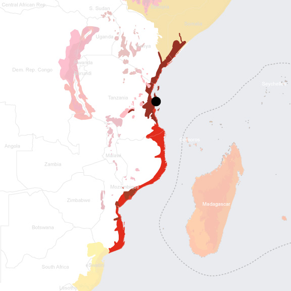
- Ecoregion: Northern Zanzibar-Inhambane Coastal Forest Mosaic Ecoregion (18% protected with 11.69% connectivity) and Eastern African Mangroves Ecoregion (36% protected with 22% connectivity), and it borders the East African Coral Coast Marine Ecoregion
- Population 2015: 5,116,000
- Projected population 2030: 10,760,000
- Mascot Species: hawksbill turtle (Eretmochelys imbricata), green turtle (Chelonia mydas)
- Primary Crops: African violet (40,000 varieties)[1], african spinach, chinese cabbage, sweet potato leaves, tomato, eggplant, okra, rice, banana, and papaya[2]
Endangered species
Amphibians
- Hemisus marmoratus
- Hyperolius burgessi
- Hyperolius burgessi
- Hyperolius ruvuensis
- Hyperolius ruvuensis
- Leptopelis parkeri
- Nectophrynoides laevis
- Ptychadena mossambica
- Sclerophrys xeros
- Hyperolius parkeri
- Kassina maculata
- Afrixalus fornasini
- Xenopus muelleri
- Arthroleptis stenodactylus
- Afrixalus stuhlmanni
- Amietia tenuoplicata
- Probreviceps macrodactylus
- Nectophrynoides viviparus
- Afrixalus sylvaticus
- Arthroleptis kidogo
- Arthroleptis nguruensis
- Mertensophryne loveridgei
- Mertensophryne lindneri
- Sclerophrys brauni
- Sclerophrys gutturalis
- Nectophrynoides minutus
- Nectophrynoides tornieri
- Afrixalus delicatus
- Afrixalus uluguruensis
- Breviceps mossambicus
- Probreviceps uluguruensis
- Arthroleptides yakusini
- Phrynobatrachus acridoides
- Phrynobatrachus uzungwensis
- Phrynobatrachus uzungwensis
- Hildebrandtia ornata
- Strongylopus fuelleborni
- Chiromantis xerampelina
- Boulengerula uluguruensis
- Probreviceps durirostris
- Phrynobatrachus scheffleri
- Kassina jozani
- Probreviceps loveridgei
- Hyperolius glandicolor
- Leptopelis flavomaculatus
- Arthroleptis xenodactyloides
- Chiromantis petersii
- Phrynomantis bifasciatus
- Hyperolius tuberilinguis
- Callulina kreffti
- Sclerophrys pusilla
- Callulina hanseni
- Callulina kanga
- Phrynobatrachus mababiensis
- Spelaeophryne methneri
- Schismaderma carens
- Arthroleptis reichei
- Hyperolius pusillus
- Arthroleptis affinis
- Sclerophrys brauni
- Sclerophrys steindachneri
- Mertensophryne taitana
- Nectophrynoides cryptus
- Nectophrynoides pseudotornieri
- Mertensophryne howelli
- Afrixalus quadrivittatus
- Afrixalus uluguruensis
- Hyperolius argus
- Hyperolius mariae
- Hyperolius mitchelli
- Hyperolius puncticulatus
- Hyperolius quadratomaculatus
- Kassina senegalensis
- Leptopelis vermiculatus
- Hoplophryne rogersi
- Hoplophryne uluguruensis
- Phrynobatrachus natalensis
- Phrynobatrachus ukingensis
- Amnirana galamensis
- Mertensophryne micranotis
- Ptychadena anchietae
- Ptychadena oxyrhynchus
- Ptychadena schillukorum
- Ptychadena taenioscelis
- Leptopelis argenteus
- Callulina meteora
- Boulengerula uluguruensis
- Schistometopum gregorii
- Scolecomorphus uluguruensis
- Scolecomorphus vittatus
- Amietia nutti
- Scolecomorphus kirkii
- Leptopelis flavomaculatus
- Leptopelis uluguruensis
- Phrynobatrachus ungujae
- Xenopus victorianus
- Arthroleptis lonnbergi
- Phrynobatrachus pallidus
- Leptopelis concolor
- Ptychadena nilotica
- Tomopterna cryptotis
- Hyperolius substriatus
- Ptychadena mascareniensis
- Pyxicephalus edulis
- Leptopelis grandiceps
- Leptopelis grandiceps
- Pyxicephalus angusticeps
Mammals
- Mops bakarii
- Laephotis wintoni
- Saccostomus mearnsi
- Madoqua kirkii
- Myosorex geata
- Rattus norvegicus
- Rousettus aegyptiacus
- Epomophorus minor
- Epomophorus minor
- Epomophorus minor
- Loxodonta africana
- Ichneumia albicauda
- Otocyon megalotis
- Megaptera novaeangliae
- Gerbilliscus leucogaster
- Miniopterus fraterculus
- Mops brachypterus
- Mops condylurus
- Myonycteris relicta
- Nesotragus moschatus
- Nesotragus moschatus
- Nycteris grandis
- Nycteris hispida
- Nycteris macrotis
- Nycteris thebaica
- Oryx beisa ssp. callotis
- Oryx beisa
- Ourebia ourebi
- Otomops martiensseni
- Panthera leo
- Paraxerus ochraceus
- Paraxerus palliatus
- Paraxerus palliatus
- Pipistrellus rueppellii
- Rousettus aegyptiacus
- Pseudorca crassidens
- Nycteris thebaica
- Pteropus seychellensis
- Pteropus voeltzkowi
- Raphicerus campestris
- Rhinolophus eloquens
- Rhinolophus fumigatus
- Rhinolophus landeri
- Rhinolophus simulator
- Mungos mungo
- Rhinolophus swinnyi
- Rhynchocyon petersi
- Rhynchocyon petersi
- Rhynchocyon petersi
- Herpestes ichneumon
- Glauconycteris argentata
- Crocidura luna
- Crocidura viaria
- Chaerephon bivittatus
- Nandinia binotata
- Atilax paludinosus
- Atilax paludinosus
- Bdeogale crassicauda
- Herpestes sanguineus
- Rhynchogale melleri
- Mellivora capensis
- Civettictis civetta
- Genetta servalina
- Potamochoerus larvatus
- Potamochoerus larvatus
- Potamochoerus larvatus
- Nycteris macrotis
- Elephantulus rufescens
- Neoromicia nana
- Neoromicia nana
- Tragelaphus oryx
- Uranomys ruddi
- Mops brachypterus
- Crocidura fuscomurina
- Gerbilliscus validus
- Glauconycteris variegata
- Thryonomys gregorianus
- Felis silvestris
- Mastomys natalensis
- Loxodonta africana
- Aepyceros melampus
- Dendrohyrax validus
- Dendrohyrax validus
- Dendrohyrax validus
- Dendrohyrax validus
- Dendrohyrax validus
- Pedetes surdaster
- Triaenops persicus
- Triaenops afer
- Triaenops afer
- Lycaon pictus
- Paragalago rondoensis
- Paragalago zanzibaricus
- Paragalago orinus
- Acinonyx jubatus
- Chlorocebus pygerythrus
- Peponocephala electra
- Cercopithecus mitis ssp. albogularis
- Tursiops truncatus
- Lophuromys kilonzoi
- Phacochoerus africanus
- Panthera pardus
- Scotophilus nigrita
- Paraxerus vexillarius
- Galago senegalensis ssp. sotikae
- Tursiops aduncus
- Otolemur garnettii ssp. garnettii
- Chlorocebus pygerythrus ssp. rufoviridis
- Tadarida ventralis
- Bdeogale omnivora
- Chlorocebus pygerythrus ssp. hilgerti
- Paragalago granti
- Lophuromys kilonzoi
- Dugong dugon
- Rhinolophus hildebrandtii
- Pelomys fallax
- Atelerix albiventris
- Eidolon helvum
- Myomyscus brockmani
- Paragalago zanzibaricus
- Paragalago orinus
- Helogale parvula
- Paragalago orinus
- Paragalago zanzibaricus
- Stenella longirostris
- Balaenoptera musculus
- Leptailurus serval
- Smutsia temminckii
- Cercopithecus mitis ssp. monoides
- Galago senegalensis
- Galago senegalensis ssp. braccatus
- Galago senegalensis
- Otolemur garnettii
- Otolemur garnettii
- Chlorocebus pygerythrus
- Panthera pardus
- Rhinopoma macinnesi
- Chlorocebus pygerythrus ssp. hilgerti
- Chlorocebus pygerythrus ssp. nesiotes
- Otolemur garnettii
- Otolemur garnettii ssp. panganiensis
- Scotoecus albofuscus
- Cercopithecus mitis
- Cercopithecus mitis
- Physeter macrocephalus
- Chlorocebus pygerythrus
- Chlorocebus pygerythrus ssp. nesiotes
- Equus quagga
- Chaerephon pumilus
- Cercopithecus mitis
- Cercopithecus mitis
- Otolemur garnettii
- Pipistrellus permixtus
- Piliocolobus kirkii
- Piliocolobus kirkii
- Cercopithecus mitis ssp. albogularis
- Neoromicia melckorum
- Chlorocebus pygerythrus
- Otolemur garnettii ssp. garnettii
- Otolemur garnettii ssp. garnettii
- Otolemur crassicaudatus
- Cercopithecus mitis ssp. albogularis
- Chlorocebus pygerythrus
- Nanger granti
- Dendromus nyikae
- Cephalophus adersi
- Rousettus aegyptiacus
- Cephalophus natalensis
- Giraffa camelopardalis
- Sylvisorex howelli
- Sylvisorex howelli
- Crocidura telfordi
- Syncerus caffer
- Crocidura elgonius
- Crocuta crocuta
- Grammomys dolichurus
- Grampus griseus
- Caracal caracal
- Chaerephon ansorgei
- Cephalophus adersi
- Chaerephon major
- Diceros bicornis
- Epomophorus wahlbergi
- Globicephala macrorhynchus
- Heliosciurus undulatus
- Papio cynocephalus
- Triaenops persicus
- Diceros bicornis
- Heterohyrax brucei
- Orcinus orca
- Paraxerus palliatus
- Thryonomys swinderianus
- Crocidura turba
- Tragelaphus imberbis
- Kerivoula africana
- Kerivoula lanosa
- Rhinolophus eloquens
- Graphiurus microtis
- Rousettus aegyptiacus
- Cricetomys ansorgei
- Orycteropus afer
- Cricetomys ansorgei
- Crocidura viaria
- Nandinia binotata
- Ictonyx striatus
- Poecilogale albinucha
- Civettictis civetta
- Nesotragus moschatus
- Bdeogale crassicauda
- Crocidura hildegardeae
- Rousettus lanosus
- Crocidura nanilla
- Hipposideros vittatus
- Cephalophus harveyi
- Myotis bocagii
- Neoromicia rendalli
- Neoromicia somalica
- Saccostomus campestris
- Rhynchocyon cirnei
- Scotoecus hirundo
- Hipposideros caffer
- Tragelaphus scriptus
- Tragelaphus strepsiceros
- Crocidura nigrofusca
- Lepus victoriae
- Lagenodelphis hosei
- Elephantulus brachyrhynchus
- Petrodromus tetradactylus
- Pipistrellus hesperidus
- Hipposideros gigas
- Hylomyscus arcimontensis
- Gerbilliscus robustus
- Pipistrellus grandidieri
- Grammomys selousi
- Hystrix cristata
- Hystrix africaeaustralis
- Acomys ngurui
- Dasymys incomtus
- Hipposideros cyclops
- Stenella coeruleoalba
- Steno bredanensis
- Taphozous hildegardeae
- Canis adustus
- Praomys delectorum
- Redunca redunca
- Taterillus emini
- Lemniscomys zebra
- Genetta angolensis
- Xerus rutilus
- Lissonycteris angolensis
- Miniopterus natalensis
- Ziphius cavirostris
- Mesoplodon hotaula
- Mesoplodon densirostris
- Lepus capensis
- Lophuromys flavopunctatus
- Hipposideros caffer
- Paraxerus flavovittis
- Thallomys paedulcus
- Nycteris aurita
- Sylvicapra grimmia
- Beamys hindei
- Scotophilus viridis
- Rhinolophus deckenii
- Rhinolophus landeri
- Indopacetus pacificus
- Suncus murinus
- Suncus megalura
- Genetta genetta
- Aethomys kaiseri
- Epomophorus minor
- Mus musculoides
- Rattus rattus
- Loxodonta africana
- Kerivoula argentata
- Sousa plumbea
- Neoromicia nana
- Hystrix cristata
- Stenella attenuata
- Grammomys selousi
- Balaenoptera borealis
- Anomalurus derbianus
- Kobus vardonii
- Kogia sima
- Nycteris grandis
- Genetta servalina
- Acinonyx jubatus
- Zelotomys hildegardeae
- Litocranius walleri
- Aethomys chrysophilus
- Alcelaphus buselaphus
- Aonyx capensis
- Canis mesomelas
- Cardioderma cor
- Colobus angolensis
- Dendromus mesomelas
- Herpestes sanguineus
- Feresa attenuata
- Graphiurus murinus
- Hippopotamus amphibius
- Hipposideros caffer
- Hipposideros ruber
- Hippotragus equinus
- Hyaena hyaena
- Lemniscomys rosalia
- Lavia frons
- Loxodonta africana
- Pipistrellus rusticus
- Proteles cristata
- Mastomys pernanus
- Mimetillus moloneyi
- Hippotragus niger
- Mus minutoides
- Myotis tricolor
- Myotis welwitschii
- Nesotragus moschatus
- Nycteris grandis
- Nycteris hispida
- Nycteris thebaica
- Oreotragus oreotragus
- Cricetomys ansorgei
- Heliophobius argenteocinereus
- Scotophilus dinganii
- Crocidura munissii
- Cricetomys ansorgei
- Acomys wilsoni
- Dendrohyrax arboreus
- Alcelaphus buselaphus
- Philantomba monticola
- Arvicanthis neumanni
- Balaenoptera edeni
- Genetta maculata
- Kogia breviceps
- Crocidura olivieri
- Balaenoptera acutorostrata
- Cephalophus adersi
- Kobus ellipsiprymnus
- Loxodonta africana
- Taphozous mauritianus
- Philantomba monticola
- Redunca arundinum
- Philantomba monticola
- Philantomba monticola
- Neoromicia capensis
- Crocidura hirta
- Triaenops afer
- Connochaetes taurinus
- Cloeotis percivali
- Miniopterus minor
Hotspot & Ecoregion Status
The Coastal Forests of Eastern Africa stretches along the coast of Tanzania, Kenya, Mozambique, and southern Somalia and includes several nearby islands, including Zanzibar. The hotspot vegetation includes moist forest, dry forest, coastal thicket, savanna, swamps, and mangroves. [3]
Species statistics [4]
|
|
Number of species |
Percentage/Number of endemics |
Notable species / Additional info |
|
Plants |
~4,050 |
~43% |
- African violets (Saintpaulia spp.), popular houseplant |
|
Birds |
>633 |
11 |
- Endangered Sokoke pipit ( Anthus sokokensis ) |
|
Mammals |
~200 |
11 |
- Critically Endangered Rondo dwarf galago ( Galagoides rondoensis ), Critically Endangered black rhinoceros ( Diceros bicornis ) |
|
Reptiles |
~250 |
>50 |
|
|
Amphibians |
>85 |
6 |
- Vulnerable Shimba Hills banana frog ( Afrixalus sylvaticus ) |
|
Freshwater Fishes |
~220 |
>30 |
|
|
Invertebrates |
DD |
DD |
- high endemism rate in millipedes and mollusks |
Only 10% of the original vegetation is considered pristine.
The
remaining habitat
is
primarily
threatened by agriculture, which primarily
in form of
subsistence farming that involves short-term shifting cultivation on the area’s poor soils. The development of commercial production of coconut, sisal, clove, cardamom, and cashew nut has also led to significant habitat loss in lowland coastal forests. Deforestation and overharvesting of woody materials is also driven by charcoal production, firewood collection, tourist infrastructure (e.g. hotels, residences, and attractions). Destructive extraction processes of mineral resources including gas, gemstones, iron, titanium, limestone, kaolin, and high-grade silica sands continue to threaten remaining habitats.
[5]
Northern Zanzibar-Inhambane Coastal Forest Mosaic Ecoregion
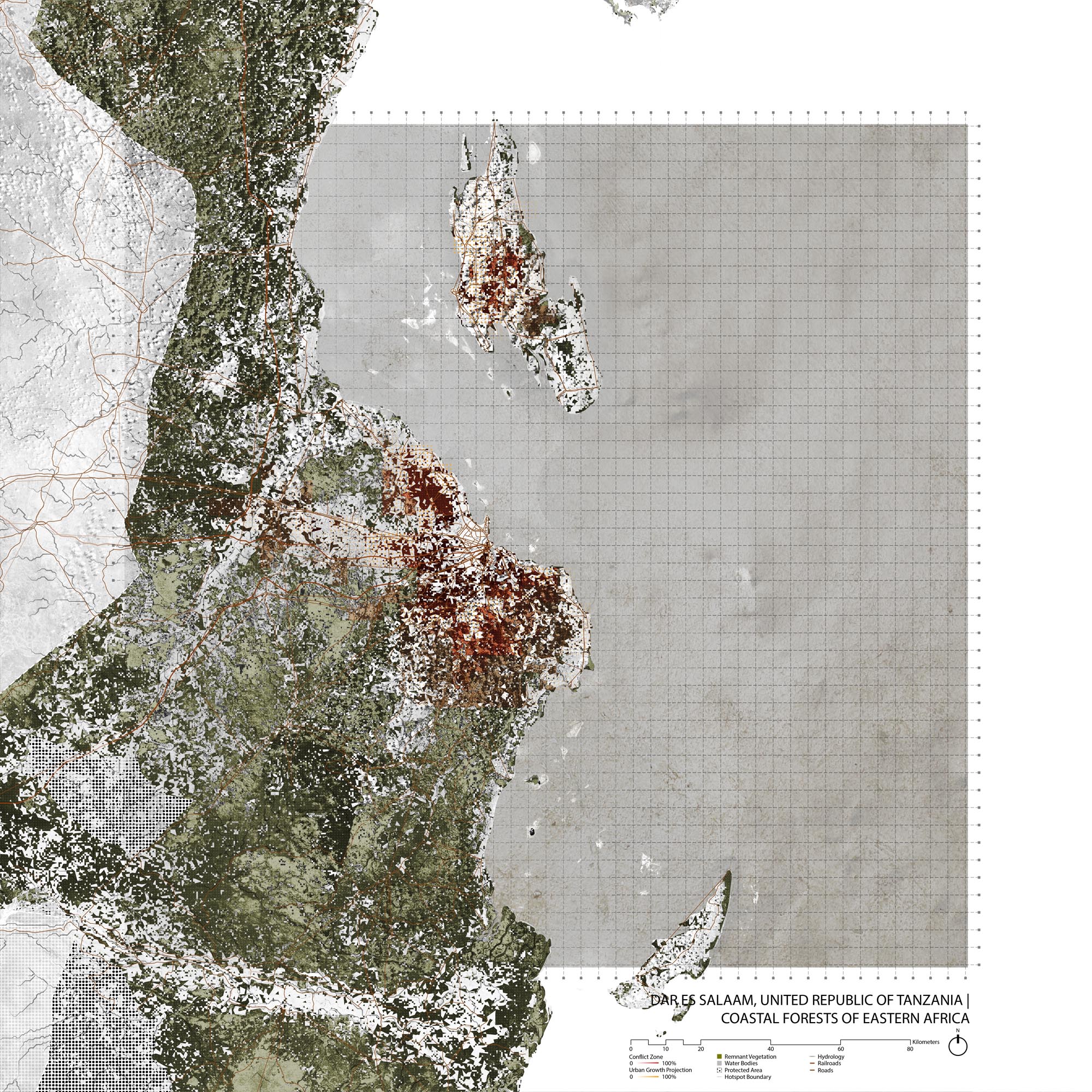
Forest Cover Change 2000-2007 Along the Coast of Tanzania

Source: Godoy, Fabiano L., Karyn Tabor, Neil D. Burgess, Boniface P. Mbilinyi, Japhet J. Kashaigili, and Marc K. Steininger. 2012. “Deforestation and CO Emissions in Coastal Tanzania from 1990 to 2007.” Environmental Conservation 39 (1): 62–71. https://doi.org/10.1017/S037689291100035X.
This ecoregion is representative of the Tropical & Subtropical Moist Broadleaf Forests biome [6] . Great soil diversity underpins the species and ecosystem diversity of this ecoregion. Taxa are rich in trees, bats, mollusks, millipedes, and primates. Most of the endemic species are forest specialists. [7] The climate varies extremely in rainfall from year to year, often shifting between drought periods and severe flooding. Yet the long-term climate has been relatively stable for as long as 30 million years. [8]
E vidence shows that forests of this ecoregion have been reduced dramatically over thousands of years due to human-driven fire regimes, replaced by the currently dominant fire-maintained savanna-woodlands. This forest loss has intensified during the last 2000 years due to farming, firewood harvest, and supplying building materials to the empires of Arabia, Portugal, Germany, and Britain. The remnant forest is highly fragmented and threatened as human activities spread due to population growth. [9] Harvesting of wood for charcoal burning around cities, especially Dar es Salaam, as well as bushland and wetland conversion to farmland and plantations for growing sisal and tree crops have also significantly undermined non-forest habitats in the region. [10] This ecoregion has met the AICHI target with 18% area protected and 11.7% terrestrial connectivity. [11]
Eastern African Mangroves Ecoregion
Although its mangroves are less extensive, the Eastern African coast has more mangrove species diversity than the Western African Coast. Large areas of well-developed mangroves are found at river mouths, especially in and around deltas. These mangroves provide habitat for migratory birds, marine turtles, dugongs, and porpoises, and enhance the biodiversity of surrounding habitats by providing shelter and food for species that live in the nutrient-poor coral reefs as well as nearby river systems. The mangroves of the Rufiji River Delta, located 200 km (120 miles) south of Dar es Salaam are one of two of the most extensive areas of mangroves in the ecoregion.
The region is highly influenced by the seasonal wind patterns of the Northeast monsoon (NEM) and Southeast monsoon (SEM), the latter occurring between April and October and is associated with heavier rainfall and more intensity. Annual rainfall in the ecoregion is between 750 and 1,500 mm. [12]
When this area was controlled by the Arabic sultans of Zanzibar, a lot of wood was harvested from the coastal mangroves for exports to the Middle East. Today, although this ecoregion has met the AICHI target with 36% area protected, and has 22.01% terrestrial connectivity [13] , its status is still considered Critical/Endangered by the WWF. Mangroves are used - often with deMafia Island Marine Parkstructive effects - for rice and shrimp farming and for timber trade. Conversion to rice paddies, saltpans, aquaculture, urbanization, and damming rivers continues. [14]
Environmental History
The long-term climate of ecoregion has remained relatively stable for up to 30 million years, despite high levels of tectonic activity. [15] Archaeological sites in Zanzibar suggest that humans have inhabited the island for at least 20,000 years. Other archaeological sites from the sixth century at the earliest indicate a settled agricultural and fishing community, while contemporary sites in and near Dar es Salaam indicate a coastal maritime culture. [16]
Zanzibar had been controlled by Portugal since the early 16th century; around the beginning of the 18th century, Omani Arabs expelled the Portuguese. As part of the Omani empire, Zanzibar became a trading center, especially for slaves, and later the capital in 1832. [17] In the 1860s, Sultan Seyyid Majid of Zanzibar formally began building a new city near the coastal fishing village Mzizima named Dar es Salaam. Dar es Salaam’s development slowed after the death of Seyyid Majid, but then restarted as the German East Africa Company established a trading station in the city and later became the capital of the German protectorate. [18] During World War I, German East Africa was taken by the British and became Tanganyika, with Dar es Salaam retaining its central position. Residential segregation that started under the Germans was legalized under the British, with different sections for Europeans and Africans. [19] Providing wood for empires such as Portugal, Britain, and Arabia historically contributed to deforestation. [20]
After World War II, Dar es Salaam experienced rapid growth. Tanganyika gained independence in 1961, and merged with Zanzibar in 1964 to form Tanzania. [21] In 1967, the Tanzanian government declared the socialist Ujamaa policy, which stagnated the potential growth of Dar es Salaam by encouraging, sometimes forcefully, people to stay in rural villages. [22] This policy failed, and subsequently liberalization replaced the socialist leanings of Tanzania’s government. Dar es Salaam starting growing substantially in the early 21st century and continues to urbanize. Dar es Salaam continues to be the primary city of Tanzania, though in 1973 the processes to relocate the capital inland to Dodoma begun.
Source: URT, 2014a. Environmental and Social Impact Assessment Report for the Proposed Infrastructure Upgrading in Unplanned Settlements in Ilala Municipality, Dar Es Salaam, Region. December 2014.
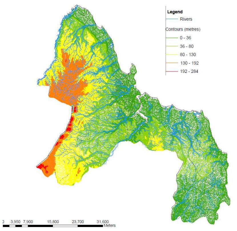
Dar es Salaam Topography
Source: URT, 2014a. Environmental and Social Impact Assessment Report for the Proposed Infrastructure Upgrading in Unplanned Settlements in Ilala Municipality, Dar Es Salaam, Region. December 2014.
The Dar es Salaam City Region has four distinct landforms: shore land that meets the Indian Ocean, the 8 to 10 km wide lime coastal plain extending from the shore to the Pugu Hills, the inland alluvial plains flowing from Pugu hills to the east and dissecting the Coastal Plain in steep sided valley that culminate in mangrove swamps before meeting the Indian Ocean, and deeply dissected hills that form the western boundary of the region ranging from 100 to 330 m.
Current Environmental Status & Major Challenges
Deforestation
The protected forest reserves in the Dar metro region have been severely degraded by urban and peri-urban expansion. The Pugu Forest Reserve, located in the south west region of the city and managed by the under District Authority, lost 30% of its forest cover between 1995 and 2010. Overall, the woodland and coastal shrub lands have become fragmented, degraded, and converted, such that all remaining contiguous habitats are at the periphery of the city. Of these forested, undeveloped areas most lack formal conservation protection, and are likely to experience fragmentation and reduction with Dar’s massive predicted growth over the next decades. [23]
Water Supply
The Pugu Forest is the headwaters of the Msimbazi River which is important for the water supply of the city. Although these headwaters are in acceptable condition, the water quality and ecological function of the river decreases at it flows through the city. This water quality issue is expected to worsen as the population living in the city’s periphery and catchment areas grows. [24] Growing extraction from limited groundwater threatens Dar’s longterm water supply. [25]
Only about 10% of the population is connected to a sewage system. This lack of sewage infrastructure leads to waste accumulation and pollution problems throughout the city. Those few sewage lines that exist dump their waste directly into the ocean with negative consequences for marine habitats and species. [26] The Msimbazi and Kizinga--two of the city’s major rivers--have are highly polluted. Sources include wastewater and industrial and drainage effluents. Sand mining of river beds and decline of forest cover point to almost certain further degradation of water quality in the future. [27]
Coastal and Marine Ecosystem Decline
Dar’s 100km coastline includes sandy beaches, rocks, cliffs, platforms, coral reefs, mangrove forests, estuaries, and seagrass-covered lagoons. In the 1960s and 70s the coral reefs in Dar’s island and bay area were found to have high diversity, but that diversity had been degraded due to destructive fishing and tourism in by the 1980s and 90s. Live coral had recovered partially by 2000, but the species composition had changed.
The mangroves throughout the coast are considered highly threatened, but especially in Temeke District which has the largest area of mangrove forest with four distinct mangrove communities covering more than 2,000km 2 . These mangrove forests as well as those in the other municipalities suffer from uncontrolled use that leads to exploitation and habitat degradation. [28]
Coastal storms and surges have resulted in extensive beach erosion.
Air pollution
Although data is limited, indicators of air quality in Dar es Salaam exceed acceptable national and WHO standards; the main pollutants are generally associated with transportation emissions, leading to prediction of continued air quality degradation with the growth of vehicle use. The coastal areas, however, seem to moderate pollution effects. [29]
Unplanned and underserved informal settlements
Many of the informal settlements occupied by 70-80% of Dar es Salaam’s overall population are located in environmentally vulnerable places such as those prone to flooding. [30]
Degradation of Natural Resources
The growing population of Dar depends on extractive activities including fishing, harvesting of trees for charcoal and household fuel, mangrove cutting, coral, sand, and salt mining, quarrying, and, to a lesser extent, harvesting medicinal plants. These activities lead to “deforestation, woodland degradation, habitat destruction, loss of biodiversity, environmental pollution, all having significant impact on catchment areas and the loss of carbon sequestration potential. Collectively, this is equivalent to a loss equal to at least 2 percent of Tanzania’s gross domestic product.” [31]
Solid Waste
About 60% of Dar’s solid waste does not get collected, resulting in water pollution and spread of disease. The high organic composition of the solid waste contributes to nutrient loading of drainage channels and rivers throughout the city.
Growth Projections + Type of Growth
Although Dar es Salaam’s growth previously lagged behind other cities in post-colonial Africa, the city has recently become on of Africa’s fastest growing urban centers. The city grew at a rate of 5.8% annually between 2004 and 2014. [32] Dar es Salaam’s current population of about 5 million is predicted to grow to as high as 21 million by 2052. [33] This unprecedented rate of urbanization, both relative to Tanzania’s history and the world, leaves authorities with little expertise and resources to accommodate the growing population. As a result, 70% of city residents live in informal communities, which is expected to pass 80% in the coming years. [34]

Source:
CityLab, “The Bright Future of Dar es Salaam, an Unlikely African Megacity,” https://www.citylab.com/design/2015/02/the-bright-future-of-dar-es-salaam-an-unlikely-african-megacity/385801/ (accessed August 13, 2018)
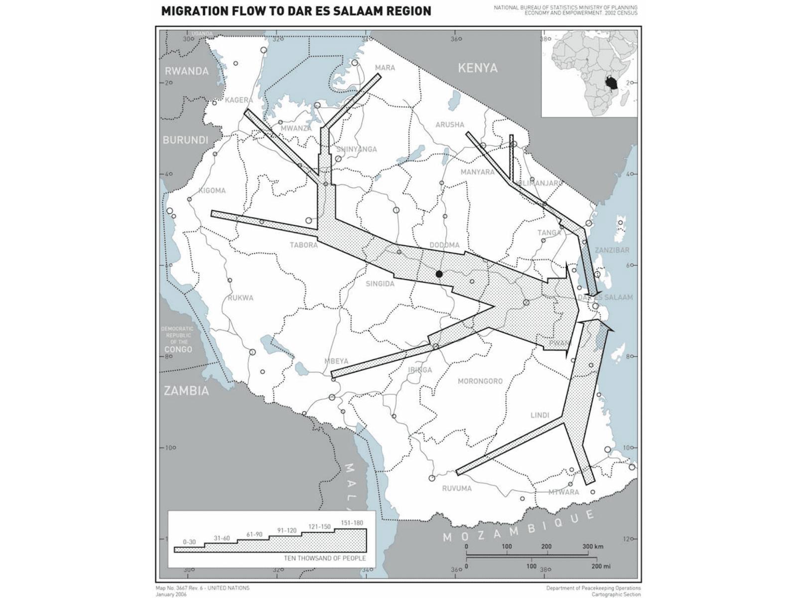
Unplanned urbanization in Dar es Salaam has resulted in large segments of the population living in flat, sprawling, areas with high flood risk. [35] Issues relating to unplanned growth also include poor waste management, lack of quality infrastructure, wetland damage. [36] Much of the population growth comes from intranational migration from rural to urban areas.
Governance
Tanzania is a Unitary Presidential Democratic Republic . T he president and members of the National Assembly are elected directly and cabinet members are chosen by the president from the National Assembly. The 10-cell lea der system of hierarchical governance was inherited from the socialist system that was replaced by the multi-party governance system in 1992. The legacy of the system in the urban setting has led to a nested system with the Dar es Salaam City council as the overarching authority followed by 3 Municipal Councils (for the municipalities if Ilala, Kinondoni, and Temeke), 73 Wards, Divisions, and 449 Streets. [38] There are separate mayors for the C ity C ouncil and each municipal council. Tanzania’s constitution established Local Government Authorities (LGA) that have powers to levy taxes and delegate sector specific fund transfers from the national government. [39] The Regional Administration Act No. 19 of 1997 established the Regional Secretariat to provide assistance to LGAs. [40] Dar es Salaam’s regional commissioner’s office, in charge of developing and coordinating the region, is located within the Prime Minister’s offic e. [41]
City Policy/Planning
Tanzania’s planning commission has released the National Tanzanian Development Vision 2025 to guide economic and social development. [42] It frames Tanzania as needed to internally improve in areas such as education, communication, and transportation to compete on a global scale. Vision 2025 also mentions improvement needed to policy implementation and institutional efficiency. Biodiversity receives little attention, except for section 3.0, “The Targets of Vision 2025.” It states that fast economic growth, one of the focuses of the section, will be pursued while reversing environmental degradation and protecting biodiversity.
The Tanzanian Draft Urban Development and Management Policy was awaiting ratification in 2018.
Development Plan
Since the 1979 master plan expired in 1999, Dar es Salaam grew for more than two decades without a master plan. [43] A Master Plan supported by the Ministry of Lands, Housing, and Human Settlements Development and a Transportation Master Plan (both commissioned by the Tanzanian Government from the Japan International Cooperation Agency) are awaiting approval at the time of this writing. The Master Plan has been revised multiple times it was initially drawn up by Burrohapold in 2010. The plan is intended to cover a 20 year period, subsequent versions were proposed but not approved from 2012-2032 [44] and 2016-2036. If approved the current plan will project land use and large scale investments out to 2039. Both plans pay attention to increasing access to transportation in order to facilitate movement and limit traffic congestion. The Master Plan mentions sees functioning natural systems as a goal of infrastructure and the environment and mentions maintaining existing community connections, though there is a lack of details metrics or targets. [45]
Zoning
The Dar es Salaam Master Plan includes the development of a Metropolitan Physical Planning Authority that function as a statutory agency, and will restructure LG A s, add flood and water infrastructure, plan urban centers including an international business zone, and develop land use zoning. [46] The new master plans includes zoning policies such as differentiated residential and industrial areas, but these maps often go against the built settlements already in existence. Residents of informal settlements fear that the plan indicates a threat of eviction and relocation as there is lack of clarity from authorities on the issue and because Tanzania has history of discriminatory zoning and forced relocation during Ujamaa. [47]
Biodiversity Policy/Planning
NBSAP
Tanzania’s current NBSAP was released in 201 5 by the Division of the Environment in the Vice President’s office. [48] The plan emphasizes the importance of var ious forest types in Tanzania, which cover about 55% of land area and have high levels of endemism. Urbanization and agricultural expansion are considered as threats . Over 90% of energy in Tanzania, both firewood and charcoal, is generated through forest resources. Habitat fragmentation, degradation, and climate change also affect the health of species. The plan acknowledges the conflict between the health of Tanzania’s ecosystems, institutional inefficiency, and economic growth. For objectives, Tanzania’s NBSAP includes mainstreaming biodiversity as a national concern, protecting and rehabilitating damaged ecosystems, and integrating conservation into Tanzania’s economic model. Initiatives mentioned include education, resource monitoring, and policy.
National
In 2015, the Ministry of Lands, Housing, and Human Settlements Development released Habitat III National Report Tanzania, which includes a section on the Environment and Urban Planning in Tanzania. [49] Biodiversity is mentioned as an issue related to both climate change and disaster-risk reduction. Sustainable forest management is mentioned frequently as a way to foster both Tanzania’s environmental health and economic growth.
The National Environmental Policy, passed in 1997, provides the framework for making fundamental changes that are needed to bring environmental considerations into the mainstream of decision-making in Tanzania. [50] The 2004 Environmental Management Act outlined Tanzania’s environmental concerns, which includes a duty to protect the environment. [51] Conservation of biological diversity, including forests, is oft mentioned as of national interests.
Regional and Local
Dar es Salaam Department of Landscape, Environment and Transport pubishes limited information on its website. [52]
Protected Areas
There are no IUCN category 1-4 protected areas in the Dar metropolitan area or for a large stretch beyond. The Ruvu North and South Forest Reserves, Kazimzumbwi National Forest Reserve, and Pugu Forest Reserve are all national forest reserves intended to be managed for sustainable timber extraction. These forest reserves have not been well managed, however, and have experienced significant deforestation.
The Pugu Forest, including the Pugu Hills Forest Reserve and Kazimzumbwi Forest Reserve, contains some of the oldest rainforest in the world , has large numbers of endemic species and plants, and is the source of th e Msimbazi River which runs through Dar es Salaam . [53] [54] This reserve extends into Dar es Salaam and is managed under District Authority control. The Pande Game Reserve protects a 1,200 ha area. The Dondwe Coast Forest to the south of the city has not been mapped. Both forests are managed by the Wildlife Division of the Ministry of Natural Resources and Tourism.
The Dar es Salaam Marine Reserve System is a group of reserves that protect coral reefs, mangroves and seagrass beds. [55]
The Kata ya Chanika (180 ha) and Kata ya Kinyerezi (67 ha) wetlands are designated protected areas. [56]
Biodiversity/Landscape Initiatives/Projects
The Tanzanian Forest Conservation Group has a multitude of projects that aim to protect Tanzania’s forest through sustainable forest practices and community integrations. There are projects in the Eastern Arc Mountains and Coastal Forests, both of which includes areas near Dar es Salaam. [57] Their scope of focus includes b iodiversity, natural heritage, water supply conserv ation and enhance ment .
The Tanzania Urban Resilience Program is part of the World Bank’s work in Tanzania. The focus is on preparing the Tanzanian government to deal with urban growth through increased data, planning, and infrastructure. Although more related to climate change, the goals of the project will help implement biodiversity initiatives and policies. [58]
Dar es Salaam Rivers Rehabilitation and Management Project (proposed)
Kinondoni Integrated Coastal Area Management Project
Public Awareness
Many of the reports and policies relating to biodiversity in Tanzania focus on educating the populace on biodiversity, which suggests lacking public awareness. The lack of communication between residents and governmental authority in Tanzania, documented mostly regarding urban development, points to difficulty in getting public awareness to translate into government action.
[1] “Coastal Forests of Eastern Africa.” CEPF. Accessed June 10, 2019. https://www.cepf.net/our-work/biodiversity-hotspots/coastal-forests-eastern-africa.
[2] City Farmer, “Vegetable Production on Open Spaces in Dar es Salaam - Spatial Changes from 1992 to 1999,” http://www.cityfarmer.org/daressalaam.html (accessed August 8, 2018); P. Jacobi et al, “Urban agriculture in Dar es Salaam,” in N. Bakker (eds) Growing Cities, Growing Food: Urban Agriculture on the Policy Agenda (DSE: Feldafing, 2000), 257-283.
[3] CEPF, “Coastal Forests of Eastern Africa,” https://www.cepf.net/our-work/biodiversity-hotspots/coastal-forests-eastern-africa (accessed August 8, 2018)
[4] “Coastal Forests of Eastern Africa: Species.” CEPF. Accessed August 8, 2018. https://www.cepf.net/our-work/biodiversity-hotspots/coastal-forests-eastern-africa/species .
[5] “Coastal Forests of Eastern Africa: Threats.” CEPF. Accessed August 8, 2018. https://www.cepf.net/our-work/biodiversity-hotspots/coastal-forests-eastern-africa/threats .
[6] “Northern Zanzibar-Inhambane Coastal Forest Mosaic.” DOPA Explorer. Accessed June 10, 2019. https://dopa-explorer.jrc.ec.europa.eu/ecoregion/30125.
[7] “Eastern Africa: Coastal Areas of Kenya, Somalia, and Tanzania.” World Wildlife Fund. Accessed August 8, 2018. https://www.worldwildlife.org/ecoregions/at0125 .
[8] Ibid.
[9] “Eastern Africa: Coastal Areas of Kenya, Somalia, and Tanzania.” World Wildlife Fund. Accessed August 8, 2018. https://www.worldwildlife.org/ecoregions/at0125 .
[10] “Eastern Africa: Coastal Areas of Kenya, Somalia, and Tanzania.” World Wildlife Fund. Accessed August 8, 2018. https://www.worldwildlife.org/ecoregions/at0125 .
[11] “Northern Zanzibar-Inhambane Coastal Forest Mosaic.” DOPA Explorer. Accessed June 10, 2019. https://dopa-explorer.jrc.ec.europa.eu/ecoregion/30125.
[12] “East African Mangroves.” World Wildlife Fund. Accessed June 10, 2019 . https://www.worldwildlife.org/ecoregions/at1402 .
[13] “East African Mangroves.” DOPA Explorer. Accessed June 10, 2019. https://dopa-explorer.jrc.ec.europa.eu/ecoregion/31402.
[14] “East African Mangroves.” World Wildlife Fund. Accessed June 10, 2019 . https://www.worldwildlife.org/ecoregions/at1402 .
[15] ibid.
[16] Chapurukha M Kusimba, Jonathan R Waltz, “When Did the Swahili Become Maritime?: A Reply to Fleisher et al. (2015), and to the Resurgence of Maritime Myopia in the Archaeology of the East African Coast,” American Anthropologist 120, no. 3 (2018): 1-15
[17] Encyclopedia Britannica, “Sultanate of Zanzibar,” https://www.britannica.com/place/Sultanate-of-Zanzibar (accessed August 10, 2018)
[18] Lonely Planet, “History,” https://www.lonelyplanet.com/tanzania/dar-es-salaam/background/history/a/nar/5af9ec40-5972-4ef8-81bc-a6fc94b1eded/355642 (accessed August 10, 2018)
[19] BlackPast, “Dar es Salaam,” http://www.blackpast.org/gah/dar-es-salaam-1857 (accessed August 10, 2018)
[20] WWF, “Eastern Africa: Coastal areas of Kenya, Somalia, and Tanzania,” https://www.worldwildlife.org/ecoregions/at0125 (accessed August 10, 2018)
[21] BlackPast, “Dar es Salaam,” http://www.blackpast.org/gah/dar-es-salaam-1857 (accessed August 10, 2018)
[22] Lonely Planet, “History,” https://www.lonelyplanet.com/tanzania/dar-es-salaam/background/history/a/nar/5af9ec40-5972-4ef8-81bc-a6fc94b1eded/355642 (accessed August 10, 2018)
[23] White, Roland. “Promoting Green Urban Development in African Cities: Dar Es Salaam, Tanzania Urban Environmental Profile.” International Bank for Reconstruction and Development/The World Bank, pp 15-17.
[24] White, Roland. “Promoting Green Urban Development in African Cities: Dar Es Salaam, Tanzania Urban Environmental Profile.” International Bank for Reconstruction and Development/The World Bank, pp 20.
[25] White, Roland. “Promoting Green Urban Development in African Cities: Dar Es Salaam, Tanzania Urban Environmental Profile.” International Bank for Reconstruction and Development/The World Bank, pp 36.
[26] “Dealing with Scare Resources: Environmental Problems in Tanzania.” World Wildlife Fund. Accessed June 10, 2019. https://wwf.panda.org/wwf_offices/tanzania/environmental_problems__in_tanzania/ .
[27] White, Roland. “Promoting Green Urban Development in African Cities: Dar Es Salaam, Tanzania Urban Environmental Profile.” International Bank for Reconstruction and Development/The World Bank, pp 20.
[28] White, Roland. “Promoting Green Urban Development in African Cities: Dar Es Salaam, Tanzania Urban Environmental Profile.” International Bank for Reconstruction and Development/The World Bank, pp 21.
[29] White, Roland. “Promoting Green Urban Development in African Cities: Dar Es Salaam, Tanzania Urban Environmental Profile.” International Bank for Reconstruction and Development/The World Bank, pp 23.
[30] White, Roland. “Promoting Green Urban Development in African Cities: Dar Es Salaam, Tanzania Urban Environmental Profile.” International Bank for Reconstruction and Development/The World Bank, pp 25.
[31] White, Roland. “Promoting Green Urban Development in African Cities: Dar Es Salaam, Tanzania Urban Environmental Profile.” International Bank for Reconstruction and Development/The World Bank, pp 28.
[32] Roy, Manoj, Riziki Shemdoe, David Hulme, Nicholaus Mwageni, and Alex Gough. “Climate Change and Declining Levels of Green Structures: Life in Informal Settlements of Dar Es Salaam, Tanzania.” Landscape and Urban Planning 180 (December 2018): 282–93. https://doi.org/10.1016/j.landurbplan.2017.11.011 .
[33] CityLab, “The Bright Future of Dar es Salaam, an Unlikely African Megacity,” https://www.citylab.com/design/2015/02/the-bright-future-of-dar-es-salaam-an-unlikely-african-megacity/385801/ (accessed August 13, 2018)
[34] Ellen-Wien Augustijn-Backers, et al., “Simulating informal settlement growth in Dar es Salaam, Tanzania: An agent-based housing model” Computers, Environment and Urban Systems 35, no. 2 (2011): 93-103
[35] The World Bank, “Problems of Population Growth and Climate Change Converge in Dar-es-Salaam,” http://www.worldbank.org/en/news/feature/2017/05/31/problems-of-population-growth-and-climate-change-converge-in-dar-es-salaam (accessed August 10, 2018)
[36] ibid.
[37] Jamiiforums, “Dar es Salaam Masterplan 2012 – 2032,” https://www.jamiiforums.com/attachments/fontanari_22_april_2013-pdf.454962/ (accessed August 13, 2018)
[38] Roy, Manoj, Riziki Shemdoe, David Hulme, Nicholaus Mwageni, and Alex Gough. “Climate Change and Declining Levels of Green Structures: Life in Informal Settlements of Dar Es Salaam, Tanzania.” Landscape and Urban Planning 180 (December 2018): 282–93. https://doi.org/10.1016/j.landurbplan.2017.11.011.
[39] Commonwealth Local Government Forum, “Tanzania,” http://www.clgf.org.uk/default/assets/File/Country_profiles/Tanzania.pdf (accessed August 10, 2018)
[40] Tanzania Online, “Strategic Plan for 2010/11 - 2012/13,” http://www.tzonline.org/pdf/strategicplan_book.pdf (accessed August 2018)
[41] Commonwealth Local Government Forum, “Tanzania,” http://www.clgf.org.uk/default/assets/File/Country_profiles/Tanzania.pdf (accessed August 10, 2018)
[42] Ministry of Finance and Planning, “Tanzania Development Vision 2025,” http://www.mipango.go.tz/index.php?option=com_docman&task=cat_view&gid=45&Itemid=62 (accessed August 15, 2018)
[43] The Citizen, “Anxiety looms as Dar master plan beckons,” http://www.thecitizen.co.tz/News/Panic-rife-in-Dar-as-June-may-herald-demolitions/-/1840340/3103990/-/2ic5kd/-/index.html (accessed August 13, 2018)
[44] “Dar es Salaam Draft Master Plan 2012-2032,”
[45] IPP Media, “draft master plan for Dar es Salaam ready,” https://www.ippmedia.com/en/news/19trn-draft-master-plan-dar-es-salaam-ready (accessed August 14, 2018)
[46] Jamiiforums, “Dar es Salaam Masterplan 2012 – 2032,” https://www.jamiiforums.com/attachments/fontanari_22_april_2013-pdf.454962/ (accessed August 13, 2018)
[47] The Citizen, “Anxiety looms as Dar master plan beckons,” http://www.thecitizen.co.tz/News/Panic-rife-in-Dar-as-June-may-herald-demolitions/-/1840340/3103990/-/2ic5kd/-/index.html (accessed August 13, 2018)
[48] CBD, “National Biodiversity Strategy and Action Plan (NBSAP) 2015-2020,” https://www.cbd.int/doc/world/tz/tz-nbsap-v2-en.pdf (accessed August 14, 2018)
[49] Habitat III, “HABITAT III NATIONAL REPORT TANZANIA,” http://habitat3.org/wp-content/uploads/Tanzania-HABITAT-III-NATIONAL-REPORT.pdf (accessed August 15, 2018)
[50] RedOrbit, “A Review of Current Tanzanian National Environmental Policy,” https://www.redorbit.com/news/science/1484000/a_review_of_current_tanzanian_national_environmental_policy/ (accessed August 15, 2018)
[51] Developmental Partners Group Tanzania, “THE ENVIRONMENTAL MANAGEMENT ACT, 2004,” http://www.tzdpg.or.tz/fileadmin/_migrated/content_uploads/Environmental_Management_Act_04.pdf (accessed August 15, 2018)
[52] City Council of Dar es Salaam, “Idara ya Mipangomiji,” http://www.dcc.go.tz/urban-planning (accessed August 15, 2018)
[53] Utalii, “Pugu Forest,” http://www.utalii.com/Dar-es-salaam/Pugu_Forest.htm (accessed August 15, 2018)
[54] White, Roland. “Promoting Green Urban Development in African Cities: Dar Es Salaam, Tanzania Urban Environmental Profile.” International Bank for Reconstruction and Development/The World Bank, n.d.
[55] Tanzania Tourist Board, “Dar es Salaam Marine Reserve,” http://tanzaniatourism.go.tz/en/destination/dar-es-salaam-marine-reserve (accessed August 15, 2018)
[56] White, Roland. “Promoting Green Urban Development in African Cities: Dar Es Salaam, Tanzania Urban Environmental Profile.” International Bank for Reconstruction and Development/The World Bank, n.d.
[57] Tanzania Forest Conservation Group, “Eastern Arc Mountain forests,” http://www.tfcg.org/where-we-work/eastern-arc-mountains/ (accessed August 15, 2018); Tanzania Forest Conservation Group, “Coastal Forests,” http://www.tfcg.org/where-we-work/coastal-forests/ ( (accessed August 15, 2018)
[58] World Bank, “Tanzania Urban Resilience Program (TURP),” http://www.worldbank.org/en/programs/tanzania-urban-resilience-program (accessed August 15, 2018)