
Mumbai, India
- Global Location plan: 19.07oN, 72.88oE
- Ecoregion: Northwestern Ghats Moist Deciduous Forests and Northwestern Ghats Montane Rain Forests
- Population 2015: 21,043,000
- Projected population 2030: 27,797,000
- Mascot Species: Tiger (Panthera tigris), Asian elephant (Elephas maximus)
Endangered species
Amphibians
- Hoplobatrachus crassus
- Microhyla rubra
- Pseudophilautus regius
- Uperodon palmatus
- Pseudophilautus maia
- Pseudophilautus abundus
- Uperodon taprobanicus
- Duttaphrynus scaber
- Microhyla ornata
- Microhyla zeylanica
- Uperodon obscurus
- Uperodon variegatus
- Uperodon systoma
- Fejervarya greenii
- Fejervarya limnocharis
- Lankanectes corrugatus
- Nannophrys ceylonensis
- Nannophrys marmorata
- Pseudophilautus auratus
- Pseudophilautus decoris
- Pseudophilautus femoralis
- Pseudophilautus fergusonianus
- Pseudophilautus folicola
- Pseudophilautus fulvus
- Pseudophilautus lunatus
- Pseudophilautus microtympanum
- Pseudophilautus reticulatus
- Pseudophilautus schmarda
- Pseudophilautus stictomerus
- Pseudophilautus mooreorum
- Pseudophilautus tanu
- Euphlyctis hexadactylus
- Pseudophilautus asankai
- Taruga longinasus
- Duttaphrynus kotagamai
- Duttaphrynus melanostictus
- Euphlyctis cyanophlyctis
- Pseudophilautus singu
- Pseudophilautus frankenbergi
- Pseudophilautus hallidayi
- Pseudophilautus hoffmanni
- Pseudophilautus mittermeieri
- Pseudophilautus poppiae
- Pseudophilautus steineri
- Pseudophilautus steineri
- Pseudophilautus stuarti
- Pseudophilautus stuarti
- Pseudophilautus cuspis
- Adenomus dasi
- Adenomus kandianus
- Adenomus kelaartii
- Duttaphrynus atukoralei
- Duttaphrynus noellerti
- Microhyla karunaratnei
- Uperodon nagaoi
- Fejervarya kirtisinghei
- Indosylvirana aurantiaca
- Hydrophylax gracilis
- Indosylvirana temporalis
- Sphaerotheca rolandae
- Pseudophilautus adspersus
- Pseudophilautus alto
- Pseudophilautus auratus
- Pseudophilautus caeruleus
- Pseudophilautus cavirostris
- Pseudophilautus dimbullae
- Pseudophilautus eximius
- Pseudophilautus halyi
- Pseudophilautus hoipolloi
- Pseudophilautus limbus
- Pseudophilautus macropus
- Pseudophilautus nemus
- Pseudophilautus ocularis
- Pseudophilautus papillosus
- Pseudophilautus pleurotaenia
- Pseudophilautus popularis
- Pseudophilautus procax
- Pseudophilautus rus
- Pseudophilautus sarasinorum
- Pseudophilautus semiruber
- Pseudophilautus silus
- Pseudophilautus simba
- Pseudophilautus sordidus
- Pseudophilautus stellatus
- Pseudophilautus silvaticus
- Raorchestes viridis
- Pseudophilautus zimmeri
- Pseudophilautus zorro
- Polypedates cruciger
- Taruga eques
- Taruga fastigo
- Polypedates maculatus
- Ichthyophis glutinosus
- Ichthyophis orthoplicatus
- Ichthyophis pseudangularis
- Sphaerotheca breviceps
- Nannophrys naeyakai
Mammals
- Funambulus layardi
- Macaca sinica
- Lutra lutra
- Golunda ellioti
- Hipposideros speoris
- Myotis hasseltii
- Megaptera novaeangliae
- Mesoplodon ginkgodens
- Prionailurus viverrinus
- Pseudorca crassidens
- Lepus nigricollis
- Viverricula indica
- Axis porcinus
- Loris lydekkerianus
- Loris lydekkerianus
- Megaderma spasma
- Herpestes smithii
- Tatera indica
- Muntiacus vaginalis
- Miniopterus schreibersii
- Balaenoptera omurai
- Moschiola kathygre
- Kerivoula picta
- Manis crassicaudata
- Peponocephala electra
- Tursiops truncatus
- Petinomys fuscocapillus
- Panthera pardus
- Tursiops aduncus
- Hesperoptenus tickelli
- Taphozous melanopogon
- Dugong dugon
- Stenella longirostris
- Balaenoptera musculus
- Hipposideros galeritus
- Rhinolophus beddomei
- Rattus montanus
- Pipistrellus ceylonicus
- Physeter macrocephalus
- Vandeleuria nolthenii
- Cynopterus sphinx
- Hypsugo affinis
- Pipistrellus tenuis
- Rhinolophus rouxii
- Scotophilus kuhlii
- Loris tardigradus
- Pipistrellus coromandra
- Cynopterus brachyotis
- Srilankamys ohiensis
- Suncus zeylanicus
- Trachypithecus vetulus
- Trachypithecus vetulus
- Trachypithecus vetulus
- Crocidura miya
- Scotophilus heathii
- Sus scrofa
- Panthera pardus
- Madromys blanfordi
- Herpestes edwardsii
- Mus mayori
- Mus musculus
- Macaca sinica
- Suncus etruscus
- Grampus griseus
- Chaerephon plicatus
- Felis chaus
- Suncus fellowesgordoni
- Globicephala macrorhynchus
- Hipposideros lankadiva
- Saccolaimus saccolaimus
- Semnopithecus priam
- Ratufa macroura
- Vandeleuria oleracea
- Hipposideros fulvus
- Orcinus orca
- Crocidura horsfieldii
- Melursus ursinus
- Petaurista philippensis
- Herpestes vitticollis
- Trachypithecus vetulus
- Taphozous longimanus
- Bubalus arnee
- Hipposideros ater
- Suncus montanus
- Funambulus palmarum
- Loris tardigradus
- Solisorex pearsoni
- Rusa unicolor
- Herpestes fuscus
- Paradoxurus zeylonensis
- Lagenodelphis hosei
- Crocidura hikmiya
- Hystrix indica
- Stenella coeruleoalba
- Steno bredanensis
- Rousettus leschenaultii
- Ziphius cavirostris
- Mesoplodon hotaula
- Mesoplodon hotaula
- Mesoplodon densirostris
- Delphinus capensis
- Paradoxurus hermaphroditus
- Indopacetus pacificus
- Suncus murinus
- Moschiola meminna
- Neophocaena phocaenoides
- Macaca sinica
- Rattus rattus
- Sousa plumbea
- Mus booduga
- Stenella attenuata
- Tadarida aegyptiaca
- Kogia sima
- Axis axis
- Bandicota bengalensis
- Feresa attenuata
- Prionailurus rubiginosus
- Pteropus giganteus
- Melursus ursinus
- Millardia meltada
- Mus fernandoni
- Murina cyclotis
- Elephas maximus
- Bandicota indica
- Balaenoptera edeni
- Funambulus sublineatus
- Kogia breviceps
- Funambulus sublineatus
- Balaenoptera acutorostrata
- Kerivoula hardwickii
- Megaderma lyra
Hotspot & Ecoregion Status
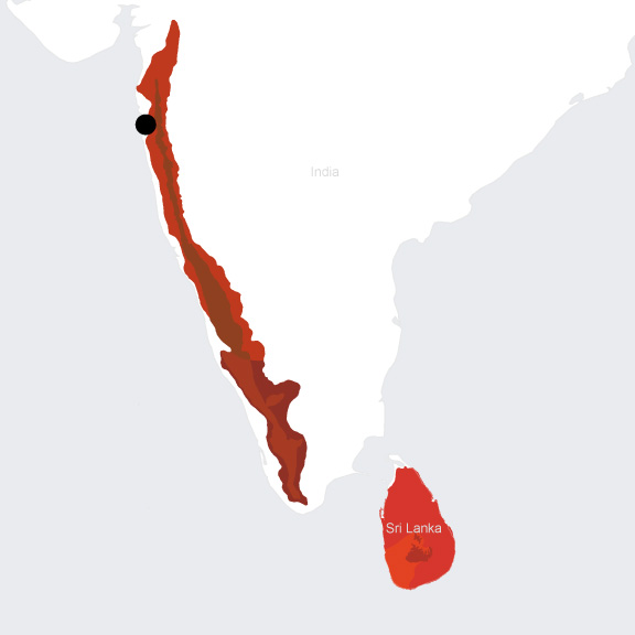
Mumbai and its metropolitan region are in the Western Ghats and Sri Lanka hotspot . The Western Ghats and Sri Lanka Biodiversity Hotspot runs along the Indian west coast and includes the Sri Lanka island. Although the area accounts for less than 6 percent of India’s national land area, it contains more than 30 percent of all flora and taxa found in the country, in part because of the varying effects of monsoons and the high mountains. Additionally, the region is home to a myriad of social, religious, and linguistic groups. The hotspot is also the center of diversity for some of the world’s most economically significant plants such as mango, banana, black pepper, and nutmeg. [1]
Species statistics [2]
|
|
Number of species |
Percentage of endemics |
Notable species / Additional info |
|
Plants |
4,000 |
~38% |
|
|
Birds |
508 |
64% |
|
|
Mammals |
|
|
|
|
Reptiles |
~157 |
~50% |
- Uropeltid snakes ( Uropeltidae ) |
|
Amphibians |
~126 |
DD |
|
|
Freshwater Fishes |
DD |
DD |
- many non-native species naturalized |
|
Invertebrates |
DD |
DD |
|
There are several centers of plant endemism in Western Ghats, the Nilgiri Mountains being one of them. The hotspot has the highest levels of amphibian endemicity in India as well. The Evergreen forests support more than 80 percent of the hotspot’s reptiles. Amongst birds, almost a third are aquatic species. Wide-ranging and flagship mammals like the Endangered tiger ( Panthera tigris ) and Endangered elephant ( Elephas maximus ) roam in the hotspot and have attracted significant conservation efforts. In contrast, relatively little is known about the distribution and status of smaller mammals, particularly small carnivores and rodents. [3]
Main threats to biodiversity in the hotspot contain livestock grazing (cattle and goats), extraction of non-timber forest products (NTFP) for subsistence and commerce, fuelwood and fodder harvest. These activities all accompany the increasing growth and high density of human population in the hotspot. Moreover, human-wildlife conflicts are common due to the vicinity of sanctuaries and villages. Villagers regularly lose crops and livestock to elephants and predators. Illegal hunting by tradition or demand for wild meat (nonessential part of the diet) is also a pervasive issue. Finally, Western Ghats are today dominated by agroforestry systems like tea, coffee, rubber, oil palm plantations and other various monocultures, leading to habitat loss. [4]
CEPF’s US$6 million investment from 2008-2015 focused only on the Western Ghats portion of the hotspot. While the funds enabled some smaller and newer organizations to grow, the most significant impact was bringing together larger groups with complementary capacities and sometimes even conflicting perspectives. This was facilitated by CEPF’s regional implementation team in the hotspot, Ashoka Trust for Research in Ecology & Environment (ATREE). [5]
Malabar Coast Moist Forests
The Mumbai metropolitan region coincides with three ecoregions. Originating from Malabar Coast Moist Forests, Mumbai's urban growth enters the Northwestern Ghats Moist Deciduous Forests, and reaches Northwestern Ghats Montane Rain Forests at its urban periphery. The Malabar Coast Moist Forest ecoregion extends along the western coast of the Deccan Peninsula between the Western Ghats Mountains and the Indian Ocean. It was tropical evergreen but has become semi-evergreen due to anthropogenic vegetation alteration. The southwestern monsoon brings more than 2,500 mm of annual rainfall to the region, wettest in the south and gradually trending towards drier conditions to the north. Mammal fauna is the most significant in the region, although at present the fragmented states of habitat no longer allows free roaming of large species. More than 95 percent of the natural vegetation cover has been cleared or converted. Plantations of coconut, areca palm, teak, rosewood, and rubber and rice paddies are widespread. Except for small patches preserved by locals as sacred groves, no large blocks of intact forests remain. Other threats include livestock grazing, trampling, fires, hydroelectric projects, and road construction. [6] Currently, only 4 percent of the ecoregion is protected, and 1.66 percent terrestrially connected. [7]
Northwestern Ghats Moist Deciduous Forests
The Northwestern Ghats Moist Deciduous Forests surround the montane rainforests in the northern section of the Western Ghats Mountains, extending through Maharashtra and Karnataka States in western India. Mean annual temperature of the ecoregion ranges from 24 to 27°C, but maximum temperatures can exceed 40°C inland. Rainfall ranges from 1,500 to 2,000 mm annually, with summer monsoons and a 4- to 5-month dry season. The ecoregion harbors many of the large herbivores and several threatened predatory mammals, including the tiger ( Panthera tigris ), Asian elephant ( Elephas maximus ), gaur ( Bos gaurus ), and slender loris ( Loris tardigradus ). The bird fauna is rich with more than 345 species, and the ecoregion overlaps with an EBA, Western Ghats, identified by BirdLife International. More than 75 percent of the natural habitat in the region has been wiped out or converted, and only scattered fragments remain. Forest clearing and human encroachment are the biggest threats to the local biodiversity; large areas have been transformed into plantations of rubber, tea, and coffee. Poaching is also a serious problem. [8] Currently, 5 percent of the ecoregion is protected, and 2 percent terrestrially connected. [9]
Northwestern Ghats Montane Rain Forests
The Northwestern Ghats Montane Rain Forests stretches across the states of Tamil Nadu, Kerala, Karnataka, and Maharashtra in western India. The ecoregion includes the middle- and upper-elevation biomes of the North Western Ghats Mountain Range. Annual rainfall averages more than 2,500 mm along the windward western slopes, and three large rivers – the Godavari, Krishna, and Cauvery – carry the precipitation from the monsoons eastward. The deeply dissected terrain produces localized variations in moisture and creates centers of endemism. The rainforests are formed with tall trees exceeding 45 m and are replete with climbers like lianas and epiphytes (orchids particularly abundant). Bamboos, palms, and canes form a dense understory, and the ground is also heavily carpeted with species. The southern part of the ecoregion is included within a high-priority tiger conservation unit (TCU). More than 58 percent of the original vegetation in the ecoregion has been cleared. Habitat loss and fragmentation are especially severe in the northern sections, close to the large cities of Mumbai and Pune. Major threats to biodiversity come from agriculture, mining (for iron and manganese ore), hydroelectric projects, and urban expansion. Many valleys have been submerged by reservoirs created by dams. Associated with those dam constructions, secondary activities such as road building, extension of access and settlements have exacerbated the degradation. Other sources of damage, like fuelwood and fodder collection, grazing, and collection of non-timber forest products are also increasing as rural populations grow. [10] Today, 17 percent of the ecoregion is under protection, and 8.12 percent is terrestrially connected. The largest single-block protected area is the Dandeli, designated as a Sanctuary at national level in 1987. [11]
Environmental History
Mumbai has its geologic origins through the separation of the Deccan plate from Gondwanaland. [12] The Deccan plate then drifted northward and merged with the Eurasian continent, creating the Indian Subcontinent. The steep Western Ghats were created by geologic uplift, which blocks the southwestern monsoon rains that come from June to September. As a result, the western side of the Western ghats receives up to 2,500 mm of rainfall per year. [13]
Mumbai is built o n land that was once a seven-island archipelago off the Konkan coast in the Arabian Sea. [14] The first known inhabitants of Mumbai were an indigenous fishing community called the Koli, who traded with Egypt and Persia. Starting in the third century BCE with the Mauryan dynasty and ending with the Gujarat Sultanate, the islands were controlled by successive Buddhist, Hindu, and Muslim empires. [15] Colonial rule began in 1534 when the islands were ceded to Portugal as part of a peace treaty. The British took control of the islands in 1661 as part of a marriage settlement. At that point, the population was 10,000 people. In 1668, the English East India Company was awarded Mumbai, at that point called Bombay.
Under Gerald Aungier, the Governor of Bombay from 1669 to 1677, Bombay was transformed into a commercial hub by expanding the harbor and offering business incentives to attract merchants. [16] In 1686, the East India Company moved its headquarters from Surat to Bombay. This commercial growth coincided with massive population growth, which stressed the islands’ residents. Multiple large scale civil engineering projects were undertaken in order to better protect its residents from the water and monsoons. Starting with Hornby Vellard reclamation projec t in 1784 and ending with the causeway connecting the Mahim and Bandra islands in 1845, Mumbai was consolidated into one landmass. [17] Various reclamation projects continued until 1990. Control of India was transferred from the Company to the Crown in 1858.
Port expansion and development increased with the opening of the Suez Canal in 1869, which made maritime trade easier between India and Europe. [18] The Bombay City Improvement Trust, created in 1898 in order to ease the population congestion of a rapidly growing Bombay, created its first suburban development plan. [19] Suburban development boomed in the postwar years while the Greater Bombay District was created as a merger of the Bombay Suburbs and the city of Bombay. [20] India gained independence from the British Empire on 15 August 1947. The Jawaharlal Nehru Port was commissioned on 26 May 1989 to greatly expand Bombay’s cargo capacity. [21] Bombay was renamed Mumbai in 1996. Today Mumbai is one of the largest cities in the world and is a center for Indian commerce, yet it is threatened by poor environmental conditions and lackluster water management.
Current Environmental Status & Major Challenges
In urban areas, Mumbai faces similar environmental issues to other megacities. Mumbai is the 4th most polluted city in the world, after only Delhi, Cairo, and Dhaka. [22] Construction activities, vehicle emissions, and garbage burning are the leading contributors to the dangerous air pollution. Flooding is a huge problem for Mumbai as monsoon rains are worsening due to climate change and Mumbai’s urban design and infrastructure are not adequate to adapt and mitigate these large flood events. [23] The drastic loss of mangrove forests also makes Mumbai more vulnerable to flooding. [24]
Growth Projections + Type of Growth
Mumbai is one of the largest urban agglomerations in the world. The city, including Mumbai City and Mumbai Suburban districts, contains over 12 million people, the sixth most populous in the world, while the greater urban area contains over 21 million. [25] The population of Mumbai has more than doubled since 1991. [26] Mumbai’s explosive growth can be attributed to migration, especially national migrations as people travel from other regions to take part in Mumbai’s economic growth.
Mumbai is also one of the most densely populated cities in the world. There are 28,000 people per square kilometer (73,000 per square mile). Approximately 41.3% of Mumbai’s population lives in informal settlements. [27] Dharavi, the largest informal settlement in India at a population of one million, reaches 334,728 people square kilometer or 869,565 people per square mile. [28] Suburban areas and poorer areas, however, have experienced the fastest growth in Mumbai’s metropolitan area. The Malad-Dahisar region in the west and the Cembur-Govandi region in the east have grown between 17% and 20% in the last decade. [29] This growth, in addition to Mumbai’s rising real estate prices, is putting a massive strain on the already dense informal settlements.
Governance
Mumbai is the capital city of Maharashtra, a state in India. Mumbai City and Mumbai Suburban districts are governed as one entity by the Municipal Corporation of Greater Mumbai (MCGM). Mumbai’s civic and infrastructural needs are MCGM’s responsibilities. MCGM is composed of 227 directly elected councillors and chaired by the Mayor of Mumbai, which is mostly a ceremonial position and who is indirectly elected by the councillors. While Municipal Corporation is the lawmaking body, the Municipal Commissioner is the executive officer of Mumbai. There are 7 zones in Mumbai, which each contain 3-5 wards. The Mumbai Metropolitan Region Development Authority (MMRDA) is similar to the MCGM but its powers extend for the Mumbai Metropolitan Region.
The Indian government ministry in charge of biodiversity and climate change programs is the Ministry of Environment, Forest, and Climate Change (MoEFCC, previously known as the Ministry of Environment and Forests). They are responsible for the administration of National Parks, surveys of flora and fauna, land conservation, and environmental management, among other roles. [30]
City Policy/Planning
Development Plan
Mumbai’s current development plan is Mumbai Development Plan 2034 (DP 2034). There does not seem to be an english copy available online. MCGM is required to come up with a development plan that lasts for 20 years and the most current draft of DP 2034 was released to the public in 2017. The plan aims to balance the needs of residential and commercial real estate development while creating jobs and affordable housing. [31] The plan includes raising the allotted floor space index and opening previously restricted land to development housing. The latter move has been criticized from endangering the ecologically sensitive salt pan lands and open space in the already crowded city. [32] There is little to no infrastructure plans to deal with the increased development, such as drainage and flood protection. [33] DP 2034 uses developer incentives to building social infrastructure [34]
Poor implementation have marred these plans’ visions. Two previous DPS, those of 1964 and 1991, only achieved about ⅓ of their implementation. [35] There is also no monitoring program to ensure DP 2034’s proper execution. [36]
Zoning
Mumbai had long been without many effective zoning laws. As a result, haphazard, congested areas make up the urban landscape with a severe lack of open space. [37] DP 2034 has provided new land use zoning provisions and building regulations that will hopefully control Mumbai’s growth. The floor space index is the main zoning instrument for the city. The DP has also added several zones like residential, commercial, industrial, no-development zones and natural areas. [38] Natural areas is an entirely new zone type.
Biodiversity Policy/Planning
NBSAP
India’s most recent NBSAP was released in 2008, prepared by India’s Ministry of Environment and Forests (now the MoEFCC). [39] There was a 2014 addendum that aligns the 2008 NBSAP with the Strategic Plan for Biodiversity 2011-2020 and the Aichi Biodiversity targets. [40] The plan presents India’s diversity of cultures and biological features as one of the main challenges to implementing programs to save biodiversity. To adequately address the multitude of different issues which biodiversity faces across India, the Ministry of Forest and the Environment created 33 state level, 10 ecoregion level, 18 local level, and 13 thematic action plans. The plan includes various design, fiscal, and legal instruments to address biodiversity in an interdisciplinary way.
National
The duty to protect and improve natural resources, wildlife, and the environment is in India’s constitution. [41] In planning, promoting, coordinating, and overseeing India’s policy and programs regarding the environment, MoEFCC is guided by multiple laws and policies. [42] The National Biodiversity Authority is an autonomous and statutory body of the MoEFCC.
National Conservation Strategy and Policy Statement on Environment and Development, 1992 and National Environment Policy 2006 are two main bills that include policies for environmental management regarding sustainable development and intend to mainstream environmental concerns. [43] The Biological Diversity Act in 2002 was born in the aftermath of the United Nations Convention on Biological Diversity in 1992. It aims to provide the conservation of biodiversity, knowledge related to India’s unique biodiversity, to foster its sustainable use, and have biodiversity’s benefits distributed equitably. [44] The act was followed by the Biological Diversity Rules in 2004 that detailed how the National Biodiversity Authority is to run. [45]
Coastal Regulation Zones (CRZ) are land management mechanisms issued by MoEFCC that aim to conserve the ecologically sensitive coast and protect the livelihoods of the people living in coastal areas. [46] There are four types of zones that allow different uses, such as development, fishing, or agriculture, in different landscapes and urban settings. This is especially important in dense Mumbai, where sustainable practices are needed for a healthy coastal environment.
Regional and Local
The main regional biodiversity bodies are the State Biodiversity Boards (SBB), functioning in all 29 Indian states. SBB’s purposes are to advise the state governments on sustainable use of biodiversity resources, regulate the commercial utilization of biodiversity, and other functions to support the provisions in the Biological Diversity Act. [47] Biodiversity Management Committees (BMC) also function in every Indian State. Their purpose is to maintain a People’s Biodiversity Register, which details information on biological resources in consultation with local people. [48]
Protected Areas
The Sanjay Gandhi National Park, formerly known as Borivali National Park, is located partly in the Mumbai suburban district and partly in the Thane District, northeast of Mumbai City. It covers around 103 spkm in highly urbanized areas and is one of the most visited parks in the world. The park includes 254 species of birds, 40 species of mammals, 78 species of reptiles and amphibians, 150 species of butterflies and over 1,300 species of plants as part of the Western Ghats biodiversity hotspot. [49] Tungareshwar Wildlife Sanctuary is located in Vasai, Palghar district. It is north of and forms a wildlife corridor with Sanjay Gandhi National Park. Tungareshwar contains Dry Deciduous, Moist Deciduous and Semi Evergreen forest types and various fauna, including a small leopard population. [50]
Biodiversity/Landscape Initiatives/Projects
In 2005, the Bombay High Court banned destruction of or dumping debris on Mumbai’s mangrove forest. [51] Since then, the Maharashtra state government has dedicated a cell to protect the 6,600 hectares of mangrove lands around Mumbai. The cell also replants mangroves and builds biofences to deter garbage dumping and store carbon dioxide and lessen pollution. Mumbai’s mangroves provide flood protection, biodiversity habitat, and livelihood for coastal communities. [52]
The National Biodiversity Authority has a host of initiatives. The Centre for Biodiversity Policy and Law (CEBPOL), a collaboration with the government of Norway, aims to provide expertise and advice on biodiversity related issues to their respective governments. Specifically, CEBPOL creates policy and laws, develops programs, and maintain accessible information on biodiversity. [53] The Strengthening Institutional Structures to Implement the Biological Diversity Act project is a collaboration between MoEFCC, United Nations Development Programme. [54] It builds capacity within government, nongovernmental organizations, and other stakeholders at various levels to better the implementation of biodiversity schemes. The website, however, does not seem to have been updated for a while.
There is also an experts database and endemic database on the National Biodiversity Authority website. [55]
[1] CEPF. “Western Ghats and Sri Lanka.” Accessed August 9, 2019. https://www.cepf.net/our-work/biodiversity-hotspots/western-ghats-and-sri-lanka.
[2] CEPF. “Western Ghats and Sri Lanka - Species.” Accessed August 9, 2019. https://www.cepf.net/our-work/biodiversity-hotspots/western-ghats-and-sri-lanka/species.
[3] CEPF. “Western Ghats and Sri Lanka - Species.” Accessed August 9, 2019. https://www.cepf.net/our-work/biodiversity-hotspots/western-ghats-and-sri-lanka/species.
[4] CEPF. “Western Ghats & Sri Lanka - Threats.” Accessed August 9, 2019. https://www.cepf.net/our-work/biodiversity-hotspots/western-ghats-and-sri-lanka/threats.
[5] CEPF. “Western Ghats and Sri Lanka.” Accessed August 9, 2019. https://www.cepf.net/our-work/biodiversity-hotspots/western-ghats-and-sri-lanka.
[6] WWF. “Southern Asia: Western India | Ecoregions.” World Wildlife Fund. Accessed August 9, 2019. https://www.worldwildlife.org/ecoregions/im0124.
[7] “Malabar Coast Moist Forests.” DOPA Explorer. Accessed August 9, 2019. https://dopa-explorer.jrc.ec.europa.eu/ecoregion/40124.
[8] WWF. “Southern Asia: Western India | Ecoregions.” World Wildlife Fund. Accessed August 9, 2019. https://www.worldwildlife.org/ecoregions/im0134.
[9] “North Western Ghats Moist Deciduous Forests.” DOPA Explorer. Accessed August 9, 2019. https://dopa-explorer.jrc.ec.europa.eu/ecoregion/40134.
[10] WWF. “Southern Asia: Southwestern India | Ecoregions.” World Wildlife Fund. Accessed August 9, 2019. https://www.worldwildlife.org/ecoregions/im0135.
[11] “North Western Ghats Montane Rain Forests.” DOPA Explorer. Accessed August 9, 2019. https://dopa-explorer.jrc.ec.europa.eu/ecoregion/40135.
[12] ibid.
[13] WWF, “Southern Asia: Western India,” https://www.worldwildlife.org/ecoregions/im0135 (Accessed May 31, 2019)
[14] Britannica, “Mumbai,” https://www.britannica.com/place/Mumbai Accessed May 31, 2019)
[15] ibid
[16] Livemint. “The East India Company: the founders of Bombay?” https://www.livemint.com/Leisure/KkeKxDetn5daogULO3TMVJ/The-East-India-Company-the-founders-of-Bombay.html (Accessed May 31, 2019)
[17] Municipal Corporation of Greater Mumbai, Disaster Management Department, “City Profile of Greater Mumbai,” https://web.archive.org/web/20150721202935/http://dm.mcgm.gov.in:9080/gmdma/wp-content/uploads/2015/pdf/city_profile.pdf (Accessed May 31, 2019)
[18] ibid
[19] Britannica, “Mumbai,” https://www.britannica.com/place/Mumbai Accessed May 31, 2019)
[20] Municipal Corporation of Greater Mumbai, Disaster Management Department, “City Profile of Greater Mumbai,” https://web.archive.org/web/20150721202935/http://dm.mcgm.gov.in:9080/gmdma/wp-content/uploads/2015/pdf/city_profile.pdf (Accessed May 31, 2019)
[21] The Hindu Business Line, “Jawaharlal Nehru Port: Charting out a steady course,” https://www.thehindubusinessline.com/2003/05/26/stories/2003052600030100.htm (Accessed May 31, 2019)
[22] Times of India, “Mumbai 4th most polluted megacity in world, 9 in 10 people breathe polluted air,” http://timesofindia.indiatimes.com/articleshow/63993044.cms (Accessed June 3, 2019)
[23] The Wire, “Here’s Why Mumbai Floods Year after Year,” https://thewire.in/urban/mumbai-heavy-rains-floods-reasons (Accessed June 3, 2019)
[24] Conservation Action Trust, “Conservation of Mangroves,” https://cat.org.in/portfolio/conservation-of-mangroves/ (Accessed June 4, 2019)
[25] Urban Hub, “Mumbai, Maharashtra, India,” http://www.urban-hub.com/cities/mumbai-maharashtra-india/ (Accessed June 2, 2019)
[26] World Population Review, “Mumbai Population 2019,” http://worldpopulationreview.com/world-cities/mumbai-population/ (Accessed June 2, 2019)
[27] ibid.
[28] Urban Hub, “Mumbai, Maharashtra, India,” http://www.urban-hub.com/cities/mumbai-maharashtra-india/ (Accessed June 2, 2019)
[29] World Population Review, “Mumbai Population 2019,” http://worldpopulationreview.com/world-cities/mumbai-population/ (Accessed June 2, 2019)
[30] Ministry of Environment, Forest, and Climate Change, “Introduction,” http://moef.gov.in/about-the-ministry/introduction-8/ (Accessed June 3, 2019)
[31] Economic Times, “Mumbai Development Plan 2034 puts focus on affordable homes and job creation,” https://economictimes.indiatimes.com/industry/services/property-/-cstruction/new-development-plan-for-mumbai-unveiled-city-to-get-more-land-for-housing/articleshow/63915163.cms (Accessed June 4, 2019)
[32] ibid.
[33] Housing, “Mumbai Development Plan 2034: Need for better implementation,” https://housing.com/news/mumbai-development-plan-2034-need-better-implementation/ (Accessed June 4, 2019)
[34] The Wire, “Mumbai's New Development Plan Is About More Real Estate for Developers,” https://thewire.in/urban/mumbais-development-plan-is-mostly-about-premier-real-estate (Accessed June 4, 2019)
[35] ibid.
[36] Housing, “Mumbai Development Plan 2034: Need for better implementation,” https://housing.com/news/mumbai-development-plan-2034-need-better-implementation/ (Accessed June 4, 2019)
[37] Times of India, “Town planning and zoning laws barely exist in Mumbai,” https://timesofindia.indiatimes.com/city/mumbai/Town-planning-and-zoning-laws-barely-exist-in-Mumbai/articleshow/14672587.cms (Accessed June 4, 2019)
[38] Economic Times, “Mumbai Development Plan 2034 puts focus on affordable homes and job creation,” https://economictimes.indiatimes.com/industry/services/property-/-cstruction/new-development-plan-for-mumbai-unveiled-city-to-get-more-land-for-housing/articleshow/63915163.cms (Accessed June 4, 2019)
[39] CBD, “National Biodiversity Action Plan,” https://www.cbd.int/doc/world/in/in-nbsap-v2-p1-en.pdf (Accessed June 4, 2019)
[40] CBD, “National Biodiversity Action Plan 2014 Addendum to NBAP 2008,” https://www.cbd.int/doc/world/in/in-nbsap-v3-en.pdf (Accessed June 4, 2019)
[41] National Portal of India, “The Constitution of India,” https://www.india.gov.in/sites/upload_files/npi/files/coi_part_full.pdf (Accessed June 4, 2019)
[42] Ministry of Environment, Forest, and Climate Change, “Introduction,” http://moef.gov.in/about-the-ministry/introduction-8/ (Accessed June 3, 2019)
[43] Prevention Web, “National Environment Policy 2006,” https://www.preventionweb.net/files/9133_2637nep2006e.pdf, (Accessed June 4, 2019)
[44] National Biodiversity Authority, “About National Biodiversity Authority,” http://nbaindia.org/content/22/2/1/aboutnba.html (Accessed June 4, 2019)
[45] ibid.
[46] 99acres, “What is a Coastal Regulation zone?” https://www.99acres.com/articles/what-is-coastal-regulation-zone.html (Accessed June 4, 2019)
[47] National Biodiversity Authority, “State Biodiversity Boards,” http://nbaindia.org/text/13/StateBiodiversityBoards.html (Accessed June 5, 2019)
[48] National Biodiversity Authority, “Biodiversity Management Committees,” http://nbaindia.org/text/14/BiodiversityManagementCommittees.html (Accessed June 5, 2019)
[49] Sanjay Gandhi National Park Mumbai, “Highlights,” https://sgnp.maharashtra.gov.in/1213/Highlights (Accessed June 5, 2019)
[50] Nature inFocus, “Tungareshwar,” https://www.natureinfocus.in/guide/tungareshwar-wls (Accessed June 5, 2019)
[51] Times of India, “Bombay High Court orders protection of mangroves,” https://timesofindia.indiatimes.com/city/mumbai/maharashtra-hc-orders-protection-of-mangroves/articleshow/65843135.cms (Accessed June 5, 2019)
[52] The Better India, “Mumbai Gets First-Of-Its-Kind Bio-Fence to Protect Mangroves From Waste,” https://www.thebetterindia.com/183802/mumbai-mangrove-protection-first-bio-fence-india-versova-innovation/ (Accessed June 5, 2019))
[53] National Biodiversity Authority, “CEBPOL,” http://nbaindia.org/content/332/31/1/cebpol.html (Accessed June 5, 2019)
[54] National Biodiversity Authority, “Background,” http://nbaindia.org/undp/ (Accessed June 5, 2019)
[55] National Biodiversity Authority, “Endemic's Database,” http://nbaindia.org/endemic_db/search.php (Accessed June 5, 2019); National Biodiversity Authority, “Taxonomy Expert's Database,” http://nbaindia.org/expert_db/search.php (Accessed June 5, 2019)
[56] Sonam Sahu & Izuru Saizen, “Development of planning index for evaluating climate change protocols: analysis of Mumbai Metropolitan Region’s Regional Plan 1996–2011,” City, Territory and Architecture 5, no. 5 (2018)